|
||

|

|
|

|
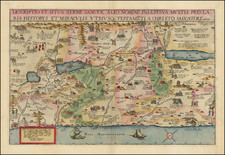
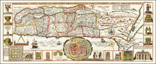
The Amsterdam Haggadah and map of the Holy Land in Hebrew.
A nice example of the 1695 first map of the Holy Land entirely in Hebrew, here in the 1781 edition.
The famed Amsterdam Haggadah is a milestone in the history of Hebrew printing and illustration, introducing a whole new iconographic approach to Haggadah illustration. Of all the early printed illustrated Passover Haggadot, the Amsterdam Haggadah of 1695 had the greatest impact on subsequent editions. The artist Abraham Bar Yaaqov, a convert to Judaism, borrowed most of the illustrations from Matthaeus Merian, a Christian artist whose illustrations for both bibles and history books were widely known throughout Europe. It was from among these engravings that the models for the illustrations in the Amsterdam Haggadah were chosen.
In his fine work on the subject, From the Ends of the Earth Judaic Treasures of the Library of Congress (New York: 1991), p.80), Abraham J. Karp notes that:
a special feature of this map, that seems heretofore unnoticed is bar Jacob's treatment of the Exodus not as leaving but returning. He depicts the traditional Goshen to the Jordan route, but adds another one beginning in Hebron and ending in Goshen, the route the family of Jacob took to Egypt. The route is marked by the only historical vignette on the map, a wagon representing those which Joseph sent to bring his family to Egypt.
Because the Haggadah was a functional prayer book, utilized at the Seder Table, the book rarely survives in good condition and more normally shows significant wear and staining, owing to the ritual use at a dinner table, around wine and food.
By the end of the fifteenth century, Hebrew books were produced using movable type. During the fifteenth century, Hebrew printing was restricted mainly to the Italian and Iberian peninsulas, where some 180 Hebrew titles were issued. While Hebrew printing ceased in Spain and Portugal after the expulsion of the Jews in 1492, it quickly spread to the Ottoman Empire, North Africa, and Central and Eastern Europe.
In 1617, the heads of the Jewish school in Amsterdam voted to establish a printing press. Within the decade, several private Hebrew presses were also set up including that operated by the renowned intellectual Menasseh ben Israel. During its first twenty years, his multilingual press produced more than sixty titles, including Bibles, prayer books, and his own original works. Well known among the philosophers, scientists, and theologians of Amsterdam, he gave sermons that attracted flocks of Christians as well as Jews, and would even represent his enterprise at the Frankfurt Book Fair in 1634.
By the close of the 17th century and throughout the 18th century, Amsterdam was the center of Hebrew printing for the entire world, supplanting Venice as the most important city for printed works in Hebrew. In addition, most of the religious literature in Spanish and Portuguese intended for the guidance of the Sephardi communities was composed and printed in Amsterdam. The Amsterdam Haggadah map is an example of the confluence of the Dutch tradition of mapmaking and illustrating Bibles with maps and the rise of Hebrew printing in Amsterdam. The influence of Dutch printing and engraving styles on the Hebrew printing and publishing business was profound.