


|
||

|

|
|

|
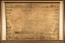
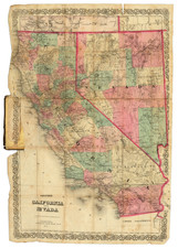
Scarce mult-sheet GLO map of California, showing the Surveyor General Office, US Land Offices, County Seats, Completed Railroads, Government Reservations (Military, Naval, Lighthouses, etc), Private Grants and a host of other details. The most notable feature of the maps is the table naming the 563 Private Land Grants, one of the few maps to name the official grants. The map is backed on two sheets of linen, as was the normal presentation in the GLO atlases of the period. A great large format map of California.
The General Land Office (GLO) refers to the independent agency in the United States that was in charge of public domain lands. Created in 1812, it assumed the responsibilities for public domain lands from the United States Department of the Treasury. The Treasury had overseen the survey of the Northwest Territory, but as more area was added to the United States, a new agency was necessary to survey the new lands.
Eventually, the GLO would be responsible for the surveying, platting, and sale of the majority of the land west of the Mississippi, with the exception of Texas. When the Secretary of the Interior was created in 1849, the GLO was placed under its authority. Until the creation of the Forest Service in 1905, the GLO also managed forest lands that had been removed from public domain. In additional to managing the fees and sales of land, the GLO produced maps and plans of the areas and plots they surveyed. In 1946, the GLO merged with the United States Grazing Service to become the Bureau of Land Management.
![Nouvelle Carte Du Mexique, Du Texas Et D'Une Partie Des Etats Limitrophes . . . 1840 [Proposed Railroads In Texas -- First Appearance of Arizona on a Printed Map]](https://storage.googleapis.com/raremaps/img/small/103480.jpg)