
![[ First State of the First Map of America ] Novae Insulae XVII Nova Tabula By Sebastian Munster](https://storage.googleapis.com/raremaps/img/small/94609.jpg)


|
||

|

|
|

|
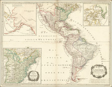
The First State of the First Printed Map of the American Continent.
The first state, first issue of Munster's map of America, the earliest map to show all of North and South America in a true continental form.
The first edition of the map appeared in Munster's Geographia, first published in 1540. However, it was the map's inclusion in the 1544 edition of Munster's Cosmographia that forever caused America to be the name of the New World, perpetuating Waldseemuller's choice of names in a popular and widely disseminated work.
Munster's map is the first to name the Pacific Ocean (Mare Pacificum). The depiction of North America is dominated by one of the most dramatic geographic misconceptions to be found on early maps-the so-called Sea of Verrazzano. The Pacific cuts deeply into North America so that the part of the coastline at this point is a narrow isthmus between two oceans. This was the result of Verrazzano mistaking the waters to the west of the Outer Banks, the long barrier islands along North Carolina as the Pacific. The division of the New World between Spain and Portugal is recognized on the map by the Castille and Leon flag planted in Puerto Rico, here called Sciana.
The map includes a host of firsts, too many to include in this description. Includes a very early appearance of the Straits of Magellan, along with his ship Victoria in the Pacific. The map includes the earliest appearance of Japan on a map, predating European contact and based solely upon legends, such as Marco Polo. The Yucatan Peninsula is shown as an Island. Lake Temistan empties into the Caribbean. The map depicts cannibals in South America and names Florida.
The misinformation provided by Verrazzano is perpetuated.
The first state of the map is rare on the market. A seminal map for American collectors.
Passage to the West and Verrazzano
Almost as soon as Europeans discovered the Americas, they eagerly searched for a passage that would allow them to traverse the continent by water. In the present map, North America is almost bisected by a large body of water jutting down through what is today Canada, leaving only a thin isthmus connecting it.
Münster’s depiction of this misconception in the present map derives from Verrazzano’s 1524 voyage. As he passed the Outer Banks of present-day North Carolina, Verrazzano thought he saw a vast “oriental sea,” sometimes referred to as the Sea of Verrazzano, leading to Cathay and the Spice Islands. What he likely saw was the long sandbar from the Pamlico to Albemarle Sounds. This misconception is depicted in several sixteenth-century European maps, including Münster’s.
This false idea of a vast eastern sea gradually transformed into the myth of a great Western Sea, centering on the story of Juan de Fuca, the Castilianized name of Greek navigator Ioánnis Fokás (Phokás). Little archival evidence survives of Fuca’s career, but a chance meeting with an English financier, Michael Lok, in Venice in 1596 gave birth to rumors of Fuca’s voyages in the Pacific. Fuca reported that he had been sent north from New Spain twice in 1592 in search of the Strait of Anian. Fuca supposedly traveled up a vast straight at the northernmost point of the west coast of America, around which he sailed for more than twenty days. The Spanish Crown failed to reward Fuca’s discovery of an opening in the coast at roughly 47° N latitude and Fuca left the Spanish service embittered. His story lived on in Lok’s letters and eventually was published in Samuel Purchas’ travel collection of 1625. Fuca’s account led to the depiction of a Western Sea in many maps of that time.
Publication of the map and states
The first state of the present map appeared in 1540 in Münster’s edition of Ptolemy’s Geographia in an added section of updated maps. Münster included a set of continental maps in this modern section, with this map representing America.
Münster then included it in his Cosmographia, starting in 1544, which was very popular, with nearly forty editions published in the following 100 years. Münster’s Cosmographia was the first influential German description of the world. The present map in its various states was the best known and most widely circulated map of the Americas until Abraham Ortelius’ map of 1570.
States of the Map
There are thirteen known states, with differences in the spelling of Atlantica in South America, the use of Temistitan and Penuco in Mexico, as well as several changes:
- State 1 1540 Atlātica Temistitan NOVVS ORBIS in North and South America
- State 2 ca. 1544 Atlātica Temistitan Regio Gigantium in South America moved to the east of the small river
- State 3 1544 Atlātica emistitan NOVVS ORBIS removed, Die Nüw Welt widely spaced
- State 4 1548 Atlantica Temistitan
- State 5 1550 Atlantica Temistitan Die Nüw... is moved lower down, and replaced by Nouus orbis
- State 6 1552 Atlantica Temistitan Latitude and longitude bars added outside the map
- Stare 7 1554 Atlantica (not present) Latitude and longitude bars removed
- State 8 1558 Atlantica (not present) Sciona from the foot of the flag is removed
- State 9 1558 oua Insula… (not present)
- State 10 1559 oua Insula… (not present) Sciona replaced, but in italics
- State 11 1561 Nova Insula… (not present)
- State 12 1569 Nova Insula… (not present) Panuco removed from the Gulf of Mexico
- State 13 1572 Nova Insula… Temistitan Panuco replaced
A significant addition to any collection of the Americas.
Sebastian Münster (1488-1552) was a cosmographer and professor of Hebrew who taught at Tübingen, Heidelberg, and Basel. He settled in the latter in 1529 and died there, of plague, in 1552. Münster made himself the center of a large network of scholars from whom he obtained geographic descriptions, maps, and directions.
As a young man, Münster joined the Franciscan order, in which he became a priest. He then studied geography at Tübingen, graduating in 1518. He moved to Basel, where he published a Hebrew grammar, one of the first books in Hebrew published in Germany. In 1521 Münster moved again, to Heidelberg, where he continued to publish Hebrew texts and the first German-produced books in Aramaic. After converting to Protestantism in 1529, he took over the chair of Hebrew at Basel, where he published his main Hebrew work, a two-volume Old Testament with a Latin translation.
Münster published his first known map, a map of Germany, in 1525. Three years later, he released a treatise on sundials. In 1540, he published Geographia universalis vetus et nova, an updated edition of Ptolemy’s Geographia. In addition to the Ptolemaic maps, Münster added 21 modern maps. One of Münster’s innovations was to include one map for each continent, a concept that would influence Ortelius and other early atlas makers. The Geographia was reprinted in 1542, 1545, and 1552.
He is best known for his Cosmographia universalis, first published in 1544 and released in at least 35 editions by 1628. It was the first German-language description of the world and contained 471 woodcuts and 26 maps over six volumes. Many of the maps were taken from the Geographia and modified over time. The Cosmographia was widely used in the sixteenth and seventeenth centuries. The text, woodcuts, and maps all influenced geographical thought for generations.
![Oceani Occidentalis Seu Terrae Novae Tabula [The Admiral's Map]](https://storage.googleapis.com/raremaps/img/small/102935.jpg)

![La America Dispuesta segun las ultimas y nuevas observationes de las Accademias, y de Paris, y de Londres [Bay or Sea of the West--Very Rare]](https://storage.googleapis.com/raremaps/img/small/75936.jpg)