This item has been sold, but you can enter your email address to be notified if another example becomes available.


|
||

|

|
|

|
Stock# 72795
Description
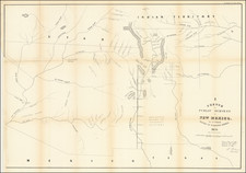
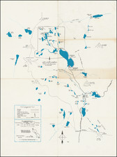
Detailed map of the American Southwest, from the Rio Grande to the Pacific Ocean focusing on the area below the Gila River.
The map details the several prospective routes for the Southern Pacific Railroad, from El Paso to Tucson and on to Yuma, San Diego and Los Angeles.
Several Copper, Gold and Silver mines are shown in New Mexico.
In California, Los Angeles, San Pedro, San Diego and San Luis Rey (Mission) appear, along with "Williams," in the general vicinity of San Bernardino.
On the Rio Grande, the following place names appear:
- Valverde
- Fort Craig
- Paraje
- Santa Barbara
- Fort Thorn
- San Diego
- Dona Anita
- Mesilla
- Las Cruces
- Fort Filmore
- Thomas
- Franklin
- El Paso
- Isletta
- Socorra
- San Elizario
The map notes further:
Official Copy of a Map Accompanying the Report of Major D. Fergusson 1st Cavalry ... on the Routes from Tucson to Libertad and Lobos Bay