|
||

|

|
|

|
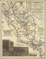
This Is Not A Hi-Way Map
Scarce historial / pictorial map of California, drawn by G.P. Dicus.
The map is both historical work and curated list of hotels, restaurants and curious attractions around California, a recommended by the artists / cartographers.
For a native Californian, the list appears to be quite eclectic and by no means that recommendations of a high budget traveler.
The map continues
Things That Help To Make Warm and Wholesome Memories Are Offered The Public By The Establishments Named Here.
No Name May Appear Unless It Has Been Carefully Selected. This is Not Just Another Business Listing of Commercial Businesses.
They Have All Been Visited By The Cartographyer and His Wife. Not Always The Biggest But Always The Best.
Sincerely, Cartographers G.P. Dicus and Bea Dicus
This would seem to be the first of the Dicus pictorial maps, followed by:
- American Indians (1952)
- Historic Old West and Southwest (1952)
- United States of America (1953)
- Mother Lode Gold Country (1953)
- A historical map of Yosemite, Sequoia, and Kings Canyon National Parks and vicinity (1953)
- California Mission Trails (1954)
- Historical map of the Redwood Empire and Trinity. Alps country (1954)
Rarity
The map is apparently quite rare. This is the first time we have ever seen the map.
There seems to be more than one edition of this map. OCLC catalogs 2 copies for 1950, 2 copies for 1954, 1 for 1858 and 1 for 1961
OCLC locates 3 copies (Library of Congress, University of Wisconsin, Milwaukee and California State Library).

![[ St. Paul, Minnesota - Harley Davidson ] Route of the Winter Carnival Grande Parade -- Saturday January 27th. 1940 . . . .](https://storage.googleapis.com/raremaps/img/small/102073.jpg)