|
||

|

|
|

|
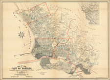
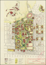
An interesting group of four maps related to the mid-1960s development of California City, California, the third-largest city in California (...by land area).
The group consists of a general map of the city, "Street Guide to California City", printed between 1968 and 1971, and three subdivision maps.
California City is one of the most quixotic development schemes ever attempted in a state that is famous for them. The inception of the city began in 1958, when Nat K. Mendelsohn purchased 82,000 acres of Mojave Desert, much of which had previously been a live-ordnance test range, with the idea of creating California's next great city. The city was initially thought to have considerable underground water resources, though this was later disproven. Mendelsohn worked hard to promote the city in spite of its remote location, and people bought land, though few actually moved in. The California City Development Company ran afoul of the FTC in the late 1960s, as well as Ralph Nader's "Raiders", but by that time, Mendelsohn had sold his shares and an estimated $100 million in real estate.
Today California City has a population density of 69 people per square mile, an astoundingly low number, and perhaps the lowest of any sizeable city in California. For instance, Palmdale, which is not far away, has a population density of 1,442 people per square mile.
The subdivision maps are titled: "Hacienda Boulevard Estates... in the city of California City"; "Mitchell Boulevard Estates in the city of California City"; and "Panorama Meadows".
![[Imperial & Coachella Valley Advertising Map -- Valerie Jean Date Shop]](https://storage.googleapis.com/raremaps/img/small/69651.jpg)