|
||

|

|
|

|
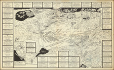
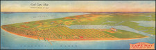
Pictorial map of the area around St. Louis, promoting the Chain of Rocks Bridge across the Mississippi River.
The pictorial map of St. Louis illustrates the main auto roads throughout St. Louis and vicinity with the Chain of Rocks Bridge in the North. The pictorial map is filled with historical and other bucolic images of the area.
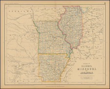
On the verso is a road map of Central United States in red blue and white, showing roads, dirt roads, state highways, U.S. highways, distances, major cities and towns.
Chain of Rocks Bridge
In 1929, the brothers John R. Scott and Tom J. Scott, established a 4 mile road from Mitchell to the east bank of the Mississippi where they had constructed an unusal toll bridge. Only twenty feet wide, the bridge had a right turn in the middle, and afforded users an unparalleled view of the Chain of Rocks and the buildings which housed the pumps for the St. Louis waterworks.
Planning the Chain of Rocks bridge began in 1924, two years before U.S. 66 was designated, as a means of shortening the trip between Chicago and St. Louis.
The curious bend in the bridgewas the result of the designers' inability to find the necessary bedrock to make a straight bridge across the river.
When the bridge on July 20, 1929, Missouri and Illinois failed to mark it on their official maps and the tolls proved insufficient to sustain the commercial venture. After 10 years, they sold the bridge to the City of Madison, Illinois in 1939.
Rand McNally & Co. is a large American map and navigation company best known for its annual atlases. The company got its start in 1856, when William Rand opened a print shop in Chicago. He was joined in 1858 by a new employee, Andrew McNally. Together, the men established their namesake company in 1868. Originally, the company was intended to print the tickets and timetables for the trains running to and through Chicago; their first railway guide was published in 1869.
By 1870, they had shifted from just printing to publishing directories, travel guides, and newspapers. Their first map appeared in 1872 in a railway guide. The map was produced using a new wax engraving method, a cheaper process that gave the company an edge.
By 1880 Rand McNally had entered the education market with globes, wall maps, and geography texts for students. In 1923, Rand McNally published the first Goode’s World Atlas, named after its editor, Dr. J. Paul Goode. For generations afterward, this would be the standard classroom atlas.
In 1899, William Rand left the company, but McNally and his family remained, controlling the company for over a century. In 1904, they published their first road map intended for automobiles and by 1907 were publishing Photo-Auto Guides, which combined photography and mapping to help drivers. In 1924, they produced the Auto Chum, a precursor to their famous road atlases. Rand McNally would remain the leader in road maps and atlases throughout the twentieth century.
In 1937, Rand McNally opened its first store in New York City. Ever on the frontier of technology, Rand McNally pioneered the scribing process for printing tickets in 1958 and printed their first full-color road atlas in 1960. Arthur Robinson developed his now-famous projection of Rand McNally in 1969. By the 1980s, the company was exploring digital reproduction and digital databases of maps for truckers. In the 1990s, they lead the charge to develop trip-planning software and websites. Today, most of its products are available online or in a digital format, including maps for tablets and phones.