|
||

|

|
|

|
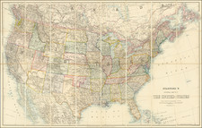
Finely Color-Printed Early American Geological Map
This is a fine large geological map of the United States, conducted by CH Hitchcock. This striking map formed part of Hitchcock's report in Transactions of the American Institute of Mining Engineers, The Geological map of the United States. This map was published during an important period in geological mapping, at a time when several national institutions were producing competing geological maps.
Hitchcock attacks the rival US Geological Survey (founded in 1879) published by McGee in 1884 stating that:
Because of the scarcity of existing and available information, it became necessary to leave the following States and Territories either partially or wholly uncolored: Arizona, California, Idaho, Montana, Nevada, New Mexico, Oregon, Texas, Utah, Washington.
In contrast, regarding this map, Hitchcock notes in his report that:
For the first time in the history of American maps it has been possible to show the distribution of stratigraphical divisions of equal importance in every part of the country.
However, Hitchcock, in conjunction with William Blake (the important Western geologist responsible for the first geological map of California), had produced a similar map 14 years earlier which had been compiled for the 9th Census. While this map shows little improvement on the earlier map, it was later separately issued in 1886, which may have driven Hitchcock to overemphasize the newness of this map.
This is not to say that the map is unimproved since the 1872-74 states. Very important progress has been made, for example, mapping extends into Canada, which shows how the old cratonic rocks of New England and Minnesota connect. Several additional classifications of rocks are included as well, for example, the Archean is divided into the (now defunct) Huronian and Laurentian Periods. Some additional information from the King and Wheeler Surveys is incorporated into the western states.
In all, this is a desirable and visually attractive geological map of the United States from the early modern era of geological mapping.
![[ Southern Railroads ] Railroad Map of the Southern States Shewing the Southern & Southwestern Railway Connections With Philadelphia. 1862 . . . Prepared by Thomas Kimber Jr., Chairman of the Committee on Inland Transportation of the Board of Trade of Philadelphia](https://storage.googleapis.com/raremaps/img/small/103211.jpg)