


|
||

|

|
|

|
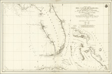
Rare Landmark Spanish Chart of Florida and the Bahamas
Large early 19th Century Sea chart of Florida and the Bahamas, published in Madrid in 1838.
Separately published by the Direcccion Hidrographica, the map is dedicated to Don Manuel de Cañas, Senior Chief of the Squadron.
Rarity
The map is scarce on the market. We note 1 example offered in AMPR in the past 20 years.
The Dirección de Hidrografía, or the Directorate of Hydrographic Works, was established in 1797. Its roots were in the Casa de Contratación, founded in 1503 in Sevilla, which housed all the charts of the Spanish Empire and oversaw the creation and maintenance of the padrón real, the official master chart. The Casa, now in Cadiz, was shuttered in 1790, but Spain still needed a hydrographic body. In response, the Dirección was created in 1797. One of its first projects was the publication of charts from the Malaspina Expedition (1789-1794). The Dirección oversaw not only publication, but also surveying. The Dirección was abolished in the early twentieth century, when their work was distributed to other organizations.

![[Cuba] Croquis de la Provincia De Puerto Principe Formado por el E. M. de la Capitania General de la Isla de Cuba ampliado y stampado en colors por el Deposito de la Guerra 1896](https://storage.googleapis.com/raremaps/img/small/33368.jpg)
![[Construction of Fort Caroline--Jacksonville, Florida] Wie die Franzosen ein gelegen Ort eine Festung zu bauwen erwehlet](https://storage.googleapis.com/raremaps/img/small/65009.jpg)