The item illustrated and described below is sold, but we
have another example in stock. To view the example which
is currently being offered for sale, click the
"View Details" button below.


|
||

|

|
|

|
Stock# 72736
Description
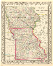
Attractive map of Missouri, published by Thomas Cowperthwait & Co.
The map is hand colored by counties and showing towns, roads, railroads, proposed rail lines, rail lines under construction, canals, steamship lines, etc. Includes township surveys and a host of other interesting details.
Just west of Missouri is Indian Territory, including over a dozen early Indian reservations.

![[ Missouri named State of Jefferson ] Etats-Unis par A.M. Perrot](https://storage.googleapis.com/raremaps/img/small/99019.jpg)