|
||

|

|
|

|
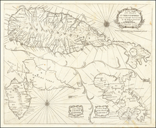
An Early Map of Cuba and Jamaica (with the Cayman Islands)
Cornelis Wytfliet's double-page engraved map of Cuba, Jamaica, Grand Cayman, Little Cayman and Cayman Brac, and the western part of Hispaniola.
The place names on Jamaica are all Spanish names, with Pa del Negrillo (Negril) the only name which survives. The treatment of Cuba is quite exceptional, with Havana, Matanzas and Puerto Principis (Nuevitas) all prominently show, along with some interior topography.
The map appeared in Cornelis Wytfliet's Descriptionis Ptolemaicae Augmentum, the first atlas to focus on the mapping of the New World.
As noted by Burden:
In 1597 Cornelis van Wytfliet published his Augmentum to Ptolemy's Geography. This is true in as much as it covers all the Americas, a part of the world unknown to the latter; however, no other connection between them exists. Dedicated to Philip III of Spain it is a history of the New World to date, recording its discovery, natural history etc. For the book Wytfliet had engraved nineteen maps, by whom we do not know, one of the world and eighteen regional maps of the Americas. . . As such this book can be truly called the first atlas of America. It was an immediate success and ran to several editions.
An essential map for regional collectors.
Cornelius de Wytfliet (ca.1550-ca. 1597) was a Flemish cartographer most famous for his Descriptionis Ptolemaicae Augmentum. The work was published in Louvain, Belgium, and had nineteen maps of the Americas.


![[Jamaica] L'Isle de la Jamaique. par M. T. J. Ingenieur Anglois a Paris, 1779](https://storage.googleapis.com/raremaps/img/small/91165.jpg)