


|
||

|

|
|

|
The Birth of the Jet Age.
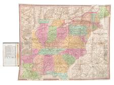
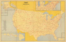
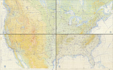
An impressive set of four large first edition "Jet Navigation Charts" covering the entire United States, issued by the U.S. Coast and Geodetic Survey and U.S. Air Force from December 18, 1953, to May 1, 1954.
The four charts constitute a complete set of maps covering the United States, which was published to aid in the nascent practice of long-haul jet aircraft flights across most or all of the country. Altogether the set is almost 9.5-feet wide and over 5.5-feet tall.
The maps were necessary because of the advances in navigation required for jets, and also because there were relatively few jet-capable airports throughout the country, and those that were worthy needed to be specifically identified. To this end, airfields such as Everett Washington (Boeing) and Burbank California (Lockheed Air Terminal and Skunkworks) show the large "J" for jet facilities, as do many of the larger coastal airbases. There are notices in red explaining how the charts can be used to navigate.
The map identifies seaplane and landplane "aerodromes", military, civil, and joint: Prohibited Areas; Danger, Restricted or Warning Areas; and Caution Areas.
The Birth of the Jet Age
While the U.S. Air Force had been working on jet aircraft starting in the early 1940s - the first U.S. jet, the Bell P-59A Airacomet, made its first flight in 1942 - it was not until the early 1950s that the technology had been deployed in large-body aircraft capable of long-haul flights across the whole country and beyond. The deployment of the Boeing B-52 Stratofortress in 1955 (with its first flight in 1952) and the Boeing 707 in 1958 (first flight in 1957) ushered in a new era of aircraft navigation, in which large distances could be covered at relatively fast speeds.
The present map represents the first large-scale U.S. Air Force Jet Navigation Chart for the whole country, and thus it is a watershed object in United States transportation cartography.
Interestingly, this chart may have been the outcome of navigational research that was being conducted in the early 1950s. An essay by John E. Murray and Rolland H. Waters, of Dunlap and Associates, Inc., titled "An Evaluation of Two Experimental Charts Designed for Navigation in High-Speed, High-Altitude Aircraft" was published in 1952, the year before these charts were made:
This paper summarizes the results of studies carried out to evaluate two experimental charts prepared as aids in navigating high-speed, high-altitude aircraft. The precise objective of the studies was to determine the relative effectiveness of the present World Aeronautical Chart (WAC) and two experimental charts, the XJN Chart produced by the Aeronautical Chart and Information Service and the XDA Chart designed by the staff of Dunlap and Associates, Inc., under the auspices of the Office of Naval Research. These charts differ in the amount, kind and method of presenting information to the pilot...
Evidently, the WAC charts were found suitable, as the present maps are WAC.
Rarity
A search of OCLC for "Jet Navigation Chart" prior to 1954 indicates that the USAF began issuing Jet Navigation Charts at a smaller scale (36x48 cm or smaller) as early as 1951. We have been unable to positively identify a set of four first edition JNCs covering the U.S. in any institution, though they surely exist.