|
||

|

|
|

|
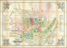
First State of Wagner's Map of Cincinnati
Fine separately published map of Cincinnati, published by A.C. Wagner Co.
This traveler’s map of Cincinnati provides the audience with nearly everything they could need to navigate the Queen City. (Note, the former nickname, “The Queen of the West” became a little outdated shortly after it was first given in 1819). Street names and block numbers are packed in nearly every available space, while a complicated network of transportation routes comprised of railways, bus routes and electric rail cars is overlaid using various colors and symbols.
Constant updates to the transit system and ongoing infrastructure improvements necessitated constant revisions – A.C. Wagner published 23 separate versions of this map between 1926 and 1954. Concentric circles indicating a mile radius from the city center are helpful for pedestrians and motorists alike, while a corresponding street index attached to the front cover provides a useful reference. Despite the surplus of information, the image is surprisingly legible, giving weight to Wagner’s claim to produce “Maps You Can Read of 50 Cities,” found on the front cover.
The map provides a detailed overview of the Queen City and neighboring parts of Covington and Newport across the Ohio River in Kentucky.
Transit lines are given in orange (along with a transit line key), along with street names, block numbers, public parks and buildings in green. Local transit lines include City (rail) Lines, Interurban (light rail) and Bus Routes.
OCL locates 23 separate versions of this map between 1926 and 1954. The first map by Wagner of Cincinnati for which we located a copyright was 1919.
![[ Ohio - Seven Ranges ] Plat of the Seven Ranges of Townships being Part of the Territory of the United States N.W. of the River Ohio which by a late act of Congress are directed to be sold . . . 1785](https://storage.googleapis.com/raremaps/img/small/82394.jpg)