The item illustrated and described below is sold, but we
have another example in stock. To view the example which
is currently being offered for sale, click the
"View Details" button below.


|
||

|

|
|

|
Stock# 7256
Description
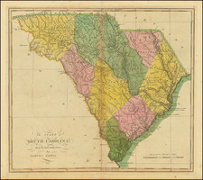
Gorgeous wide-margined example of Carey's map of South Carolina, hand colored by counties. This is the 1814 edition of Lewis' map, first issued in William Guthrie's New System of Modern Geography, published in 1795. The map provided a large format and highly detailed map of the state, showing towns, roads, rivers, mountains, swamps, counties, meeting houses, and substantial other detail. Highly detailed throughout. Very rare in full color. Carey's General Atlas published in 1814 was the first American Atlas to be offered for sale with hand coloring on the maps. A fine wide-margined example.