


|
||

|

|
|

|
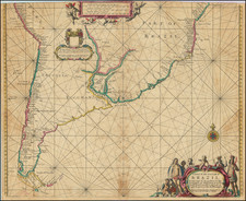
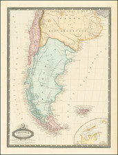
Important early map of Argentina, Uruguay and the southern part of Brazil, centered on the Rio Plata and showing its watershed and numerous early settlements.
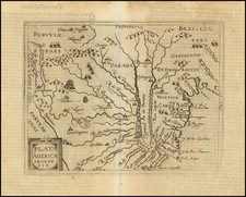
Wytfliet's Atlas was the first atlas devoted entirely to the Americas and was extremely influential on the mapping of most parts of America for the next several decades.
The first edition of Wyfliet's work is 'the first atlas of America' (Burden), and was first published in Latin in 1597. The work was marketed as a supplement to Ptolemy's Geographia, with text based on the writings of Ramusio, Hakluyt, de Bry, Acosta and others.
The book proved popular and two further Latin editions appeared in 1598 and 1603. It was then translated into French and combined with the work of Magini and others and first published under the present title in 1605. Further editions of this compilation appeared in 1607 and 1611.
When Cornelis van Wytfliet wrote a supplement to the geographical text of Ptolemy, he in effect produced the first atlas devoted entirely to the Americas...' (Goss). 'The text is entirely concerned with the discovery, natural history and geography of the New World, and the eighteen regional maps are likewise solely of this area...' (Shirley). Wytfliet's book was 'the earliest distinctively American atlas. It is as important in the history of the early cartography of the new world, as Ptolemy's maps are in the study of the old' (Philips & LeGear, 1140).
The first part of the book contains an historical survey from the discovery of America by Columbus up to about 1540. Wytfliet goes on to describe the different regions from Tierra del Fuego up to Canada. There is a series of nineteen superb double-page engraved maps, one a double-page double-hemisphere world map based on Mercator's of 1584, and the other eighteen depicting the various parts of America.
There is also a famous image of the southern continent in the form of Wytfliet's map "Chica sive Patagonica et Australis Terra". At the top the lower portion of South America is shown as being separated by a strait from a large southern continent or Southland (Australis Terrae Pars). The naming of C. Della Victoria and an illustration of Magellan's ship Victoria indicate the Strait of Magellan. The lower part of the map is shown on a polar projection, with Terra Australis a large landmass made up of four peninsulas that reach towards New Guinea (Java Maior), Africa and towards South America. Schilder discusses this map at length and points to its significance to Major, Collingridge, and others 'as proof that Australia had already been discovered in the sixteenth century...'. Wytfliet's significance in this respect continues: both his map and the accompanying text figure importantly in Kenneth McIntyre's arguments for early discoveries in Australia (Secret Discovery of Australia, pp. 234-5).
The second part of the book deals with the East Indies and was first added in the first French edition of 1605. The text, by Giovanni Antonio Magini (1555-1617) and others, deals with the discovery of the Cape of Good Hope, India, Indonesia, and Japan, followed by a geographical description of these countries.
Cornelius de Wytfliet (ca.1550-ca. 1597) was a Flemish cartographer most famous for his Descriptionis Ptolemaicae Augmentum. The work was published in Louvain, Belgium, and had nineteen maps of the Americas.