|
||

|

|
|

|
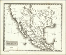
Illustrating Both The Pre- and Post-1846 Boundaries (Including part of South Texas)
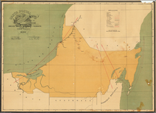
Scarce map of the State of Tamaulipas and a large swath of South Texas (roughly the area between the Nueces and Rio Grande Rivers), from Antonio Garcia y Cubas' monumental Atlas Geographico, Estadistico e Historico de la Republica Mexicana, the first atlas of the Mexican Republic.
The area between the Nueces and Rio Grande Rivers was an area of intrigue during the period when Texas was a Republic. In 1840, Tamaulipas became a part of the short-lived Republic of the Rio Grande, which lasted from January 17 to November 6, 1840. In 1848, after the Mexican–American War, Tamaulipas lost more than a quarter of its territory via the Treaty of Guadalupe-Hidalgo. American president James K. Polk had desired to annex Mexican territory as far south as Tampico although his negotiator Nicholas Trist disregarded this and settled on a border with Texas on the Rio Grande. Its capital was kept at Aguayo, which later was renamed Ciudad Victoria in honor of Guadalupe Victoria, first President of Mexico.
Garcia Cubas' map of Tamaulipas is one of the earliest maps of the modern state of Tamaulipas published in Mexico. The surrounding text includes a wealth of information regarding Tamaulipas, including History, Climate, Agriculture, Minerals, Livestock, Commerce, Population and Itineraries.
Antonio Garcia y Cubas was Mexico's first great map maker and his work is highly sought after. This map shows the various regions within Tamaulipas, including, towns, roads, rivers, etc.
Rarity
Only 300 examples of the atlas were reportedly printed and separate maps rarely appear on the market.
This is the second example of this map we have ever offered for sale.
Antonio García y Cubas (1832-1912) was a Mexican geographer, historian, writer, and cartographer. An orphan from a young age, Cubas attended the Colegio de San Gregorio and the Colegio de Ingenieros, where he earned a geography degree. In 1856, he became a member of the Sociedad Mexicana de Geografía y Estadística.
Cubas wrote several geographic works, including introductory courses to geography, historical atlases, and maps. He is best known for his Atlas Geográfico, Estadístico e Histórico de la República Mexicana (1857), Carta General de México (1863), and Diccionario Geográfico, Histórico y Biográfico de los Estados Unidos Mexicanos en cinco volúmenes, editados entre 1888 y 1891. He is also praised for his memoir, El Libro de mis Recuerdos (1905). Today, the best books published in anthropology and history in Mexico are given the Antonio García Cubas prize.
![[Texas and Western Louisiana]](https://storage.googleapis.com/raremaps/img/small/66617.jpg)