|
||

|

|
|

|
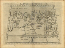
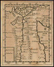
Rare edition of Ptolemy's map of Northeastern Africa, extending from Egypt and the Red Sea (Sinus Arabicus) to Libya,
Conrad Swenheym's finely engraved of Northeastern Africa and Egypt is the earliest obtainable map of the region, preceded only a map published in Bologna in 1477 which is essentially unobtainable for collectors. The map shows the region based upon the writings of the Alexandrian mapmaker Claudius Ptolemy, who flourished in the second Century A.D. and whose geographical text was translated into Latin and later inspired manuscript maps using Ptolemy's table of geographical coordinates. The earliest surviving examples of such manuscript maps date to the beginning of the 14th Century. Ultimately these maps and Ptolemy's text would be compiled to form the most influential treatise on Geography in the 15th Century, concurrently with the advent of the printing press, resulting in its widespread distribution in Europe, which ironically eclipsed the work of other Greek Geographers of the period, such as Strabo, whose work was probably more accurate than Ptolemy's calculations.
Conrad Swenheym introduced the printing press to Italy at the height of the Renaissance, having been apprenticed to Guttenberg. Initially, under the enthusiastic patronage of Pope Paul II, Swenheym concentrated on publishing texts, but later turned to producing the first illustrated Cosmographia in the early 1470s, when enthusiasm was not sustained by the Pope's successor, Sixtus IV.
Despite being beaten out by one year (for the honor of the earliest printed edition of Ptolemy's work) by Taddeo Crivelli, who published his edition in Bologna in 1477, the copper plates produced under Swenheym's close supervision, and finally printed just after his death in 1478, are considered vastly superior. The plates were then purchased by Petrus de Turre in 1490, who published the second edition, in which this map appeared. The only difference in the maps are the watermarks in the paper. A third edition was issued in 1507.
Rarity and Dating
Historically, it was difficult (if not impossible) to date separate maps from editions of the 1478/1490/1507-08 Rome Ptolemy. In 2017, R.H.J. Peerlings, F. Laurentius, and J. van den Bovenkamp undertook a study of the watermarks in the different editions of the atlas to establish a chronology of watermarks that could be used to date separate maps.
The present map has a light tau-in-circle watermark. These kinds of watermarks appeared in both the 1490 and 1507-08, though this one is apparently associated with the later edition.
Maps from all editions of the atlas are rare, though the 1478-datable maps appear to be up to an order of magnitude rarer than the later editions.
Claudius Ptolemy (fl. AD 127-145) was an ancient geographer, astronomer, and mathematician. He is known today through translations and transcriptions of his work, but little is known about his life besides his residence in Alexandria.
Several of his works are still known today, although they have passed through several alterations and languages over the centuries. The Almagest, in thirteen books, discusses astronomy. It is in the Almagest that Ptolemy postulates his geocentric universe. His geometric ideas are contained in the Analemma, and his optical ideas were presented in five books known as the Optica.
His geographic and cartographic work was immensely influential. In the Planisphaerium, Ptolemy discusses the stereographic projection. Perhaps his best-known work is his Geographia, in eight books. However, Ptolemy’s ideas had been absent from western European intellectual history for roughly a thousand years, although Arab scholars interacted with his ideas from the ninth century onward.
In 1295, a Greek monk found a copy of Geographia in Constantinople; the emperor ordered a copy made and the Greek text began to circulate in eastern Europe. In 1393, a Byzantine diplomat brought a copy of the Geographia to Italy, where it was translated into Latin in 1406 and called the Cosmographia. The manuscript maps were first recorded in 1415. These manuscripts, of which there are over eighty extant today, are the descendants of Ptolemy’s work and a now-lost atlas consisting of a world map and 26 regional maps.
When Ptolemy’s work was re-introduced to Western scholarship, it proved radically influential for the understanding and appearance of maps. Ptolemy employs the concept of a graticule, uses latitude and longitude, and orients his maps to the north—concepts we take for granted today. The Geographia’s text is concerned with three main issues with regard to geography: the size and shape of the earth; map projection, i.e. how to represent the world’s curve proportionally on a plane surface; and the corruption of spatial data as it transfers from source to source. The text also contains instructions as to how to map the world on a globe or a plane surface, complete with the only set of geographic coordinates (8000 toponyms, 6400 with coordinates) to survive from the classical world.
![(Early French Colonization of North Africa--Barbary Pirates) Gigeri en Afrique, Sur la Coste de Barbarie; et la Prise par les Armees du Roy, Commandes par Mr. le Duc de Beaufort [Gigeri in Africa, On the Coast of Barbary; and its Capture by the Armies of the King, Commanded by Mr. the Duke of Beaufort]](https://storage.googleapis.com/raremaps/img/small/93494.jpg)