|
||

|

|
|

|
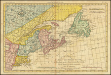
Rare Early Sea Chart from the Dutch Golden Age
Finely-colored and rare sea chart of the North Atlantic, published in Amsterdam by Johannes Van Loon.
This rare chart illustrates the waters between Northern Europe and Canada (then New France) and is centered on Greenland and Iceland. Gone are the mythical islands of earlier generations—the function of the present chart was to serve as an up-to-date, informed, and accurate navigational aid.
The toponyms along the westernmost coastlines represent encounters of European fisherman with the lands of North America, as well as the explorations of those in search of the Northwest Passage, including John Davis. Davis (ca. 1550-1605), half-brother of Sir Walter Raleigh, led three voyages to the far north (1585, 1586, 1587), specifically to Greenland, Baffin Bay, and Labrador. A note in the far northwest discusses local fauna, including whales and foxes.
Iceland was settled in the ninth century by Vikings, although it is likely a group of Hiberno-Scottish monks visited its shores before that. The Viking settlers, and their descendants, bestowed the toponyms seen here.
Icelanders and Norwegians pushed farther west, settling on the southwestern coast of Greenland in the late-tenth century. Their settlements dissipated in the fourteenth and fifteenth centuries, however, with the onset of the Little Ice Age. The Portuguese charted the southern coastline in the early sixteenth century and, at the beginning of the seventeenth century, King Christian IV of Denmark ordered a series of voyages to claim Greenland for his kingdom. These voyages, although largely unsuccessful, supplied the toponyms in the southeast shown here.
At the upper right is an early appearance of the reference to the sighting of land on the eastern coast of Greenland by Dutch navigator Gael Hamkes in 1654, with a tentative coastline extending far across the map. Today, a bay in the area carries his name.
A web of rhumb lines and ships in full sail suggest increased maritime traffic in the near future for this area. The most notable decorative feature, the cartouche, fills northern Greenland. It features a Norseman hunting walrus and seal, while an indigenous man in fur holds a kayak.
The chart featured in Van Loon’s Zee Atlas, which is among the rarest of all early Dutch sea atlases.
States of the map
Burden lists two states of the map:
- 1661: imprint of Johannes en giels van Loon plaetsnyder
- 1666: imprint of Iohannes vanLoon Plaet-snyder en Zee=caert-maker
This is an example of the latter; both states of the map are seldom seen.
Rarity
The map is very rare on the market. RBH locates only a single example at auction in the past fifty years (Sothebys 1974) and no examples in AMPR.