


|
||

|

|
|

|
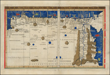
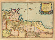
Nice example of Francesco Berlingheri's very rare map of Libya and Egypt, from his Septe Giornate della Geographia di Francesco Berlinghieri (The Seven Days of Geography), published in Florence in 1482.
The map is primarily concerned with the north African coast between the Gulf of Sidra and Israel. It extends south below the ancient port of Berenice on the Red Sea (here called "Arabico Golpho"), essentially encompassing all of modern-day Egypt and the eastern half of modern-day Libya.
The settlements adjacent to the Nile are of particular interest, as they reflect the knowledge of the Alexandria-based polymath Claudius Ptolemaeus, the second-century author of the geographical gazetteer that was the basis for the present map. As Ptolemy was based in Egypt, one may expect particularly good information of that region from him.
It is interesting to compare Berlinghieri's "Tertia" with that of Conrad Swenheym, which appeared a few years earlier in the 1478 Rome Ptolemy: www.raremaps.com/gallery/detail/34077/tertia-africae-tabula-ptolemy-swenheym
The 1478 map is superior in terms of its clarity of design and execution (a frequent compliment given to that edition re especially the 1477 Bologna Ptolemy), but the cartography cannot be called more accurate. The extensive mountain ranges, lakes and rivers, and even forests of eastern Libya and western Egypt stand in unreal contrast to the more realistic sparseness of Berlinghieri. They were clearly working from different manuscript sources, and Berlinghieri's map is much closer to the "Tertia" in Vatopedi 655, the earliest extant manuscript Ptolemy atlas produced after the work's rediscovery by Maximus Planudes in the 13th century.
While Berlingheri's map is the third printed map of Libya and Egypt (pre-dated by editions of 1477 (Bologna) and 1478 (Rome), his map is of the highest importance for several reasons. First, the map is based upon the projections of Marinus of Tyre, a second-century Greek geographer, cartographer, and mathematician, who is credited as the founder of mathematical geography, a system which would have been employed by Claudius Ptolemy at the time Ptolemy originally constructed his Geographia. Berlinghieri's was the only one of these early Ptolemy atlases to use the original projection.
Berlingheri's map is also unique in that it is the first printed map of the region to utilize a style that is notably different from the Nicholas Germanicus model and to adopt a different means for projecting the printed landmasses represented on the maps. The maps were printed by Niccolò Tedesco, a German printer (employing Marinus of Tyre's equidistant meridians and parallels). The maps also have rectangular borders rather than the trapezoidal borders employed in the earlier Bologna and Rome editions (and also the Ulm edition of 1482-1486).
The maps are also believed by some experts to be the earliest cartographic work of Francesco Rosselli, the most important Florentine mapmaker of the late 15th and early-16th centuries.
An essential map for collectors of early maps of Africa.
Francesco Berlinghieri (1440-1501) was a Florentine engraver. Nicolas Laurentii published Berlinghieri's edition of Ptolemy, which was written in Italian terza rima, comprising 123 folios of text and 31 engraved maps. The work was first printed in 1482, but most surviving examples come from the edition of 1486, which was the first edition to include red printing in the title page. The full title is Geographia. In Questo Volume Si Congengono Septe Giornate Della Geographia Di Francesco Berlingeri Fiorentino Allo Illustrissimo Federigo Duca . . .
Berlinghieri's edition of Ptolemy is unique, in that it includes 31 maps covering Europe, northern Africa and the south part of Asia and is the first atlas to attempt the introduction of modern geography, with the inclusion of four new maps - France, Italy, Spain and Palestine, which are based on contemporary knowledge. rather than a strict plotting of Ptolemy's coordinates. A number of other maps in the Berlinghieri edition of Ptolemy include data which is drawn from modern sources, albeit more subtlely so, in part because of transcription errors and in part because of corrections made over time by later scholars.
While Berlinghieri's atlas was the third Italian printed edition of Ptolemy, it was very important in other respects. Berlinghieri's Ptolemaic regional maps are drawn on Marinus' plane projection; and although not generally considered an edition of Ptolemy, the maps are the only examples of Ptolemy's maps to be drawn on the original projection, with equidistant meridians and parallels. Berlinghieri's work was also the first to include a printed Gazetteer for each of the maps.
The text by Berlingheiri is a metrical paraphrase of Ptolemy, the first atlas in the Italian language. Francesco Berlinghieri was an Italian scholar and humanisrt. He promoted the value of classical Greek learning and therefore was the first to print an edition of Ptolemy in vernacular Italian, rather than Latin. The maps look distorted as compared to modern maps, because Ptolemy's data was inaccurate. One reason is that Ptolemy estimated the size of the Earth as too small: while Eratosthenes of Cyrene, a Greek mathematician, elegiac poet, athlete, geographer, and astronomer, made several discoveries and inventions including a system of latitude and longitude and conceived the idea of 700 stadia for a degree on the globe, in the Geographia Ptolemy uses 500 stadia. It is not certain if these geographers used the same stadion, but if we assume that they both stuck to the traditional Attic stadion of about 185 meters, then the older estimate is 1/6 too large, and Ptolemy's value is 1/6 too small. Because Ptolemy derived most of his topographic coordinates by converting measured distances to angles, his maps get distorted. So his values for the latitude were in error by up to 2 degrees. For longitude this was even worse, because there was no reliable method to determine geographic longitude.
Ptolemy was well aware of this. It must be added that his original topographic list cannot be reconstructed: the long tables with numbers were transmitted to posterity through copies containing many scribal errors, and people have always been adding or improving the topographic data: this is a testimony to the persistent popularity of this influential work in the history of cartography..
As early as 1938 Arthur M. Hind, Keeper of Prints and Drawings at the British Museum, hinted that the engravings might have been made by Francesco Rosselli (1448-before 1527), the principal engraver in Florence in the 1480s and 1490s. Subsequently, this possibility was rejected by Roberto Almagiagrave, R. A. Skelton and Tony Campbell. In the author's view, however, both stylistic and circumstantial evidence argues that Francesco was indeed the engraver, and that this first major commission launched the career that eventually made him known to his contemporaries as 'Franciscus rosellus florentinus Cosmographus'.
![[ Algerian Viticulture ] Carte Viti-Vinicole de l'Algerie](https://storage.googleapis.com/raremaps/img/small/97857.jpg)
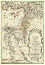
![[ Egypt ] L'Egitto Antico E Moderno . . . 1784](https://storage.googleapis.com/raremaps/img/small/97779.jpg)