|
||

|

|
|

|
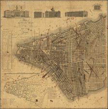
Early edition of Colton's map of New York City, based originally upon John Eddy's seminal plan of New York City.
This beautifully designed, circular map is a re-engraving of John Eddy's renowned "Map of the Country Thirty Miles round the City of New York," published in 1812. It shows the region around New York as far east as Suffolk County, Long Island, north to southern Rockland County, NY, east to Morris County, NJ, and south to Monmouth County, NJ.
This second variant edition includes engraved vignettes of the New York and Brooklyn city halls in the lower corners. The earliest variant of the map had no decorative embellishment around the map. The second variant had a floral type pattern around the map. The third edition of the map has a much simpler decorative flourish.
G. W. & C. B. Colton was a prominent family firm of mapmakers who were leaders in the American map trade in the nineteenth century. The business was founded by Joseph Hutchins Colton (1800-1893) who bought copyrights to existing maps and oversaw their production. By the 1850s, their output had expanded to include original maps, guidebooks, atlases, and railroad maps. Joseph was succeeded by his sons, George Woolworth (1827-1901) and Charles B. Colton (1831-1916). The firm was renamed G. W. & C. B. Colton as a result. George is thought responsible for their best-known work, the General Atlas, originally published under that title in 1857. In 1898, the brothers merged their business and the firm became Colton, Ohman, & Co., which operated until 1901, when August R. Ohman took on the business alone and dropped the Colton name.
![[New York Harbor]](https://storage.googleapis.com/raremaps/img/small/78897.jpg)