|
||

|

|
|

|
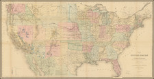
A Non-Partisan Presidential Campaign Premium Map By "Ranger Rick" Artist Lorin Thompson
Rare map of the United States was drawn by Lorin Thompson and published by the General Foods Corporation, celebrating the upcoming US Presidential election of 1960.
While the maps illustrations are relatively mundane for the period, perhaps the most provocative element of the map is the proud depiction of the "First successful atomic explosion on July 16, 1945."
The second intiguing feature is the non-partisan nature of the graphic, with a smiling donkey and elephant above the election scorecard, which notes, "let the whole family join in the fun of predicting which Presidential Candidate will win in each state. . . " It would be difficult to imagine a large corporation creating a graphic of this nature in recent presidential elections, for fear of offending some special interest group.
Map provides a rich series of illustrations of American History (the Railroad "Golden Spike" in Utah, gold mining in California, Kitty Hawk, etc.), agricultural products (tobacco, cotton, wheat) and portraits of famous U.S. Presidents (Lincoln, Washington, etc.); also iconic structures in American History (the Alamo, U.S. Capitol, Independence Hall, etc.); and engineering feats (Hoover Dam, the Statue of Liberty, Empire State Building).
Perhaps most period specific, the map proudly illustrates the testing of Atomic Bombs in New Mexico.
The verso shows a list of past presidents, pictures of the two candidates (Kennedy and Nixon), a 1960 election scoreboard, and a key to the 54 illustrations on the map on recto.
Rarity
The map is seemingly quite scarce on the market.
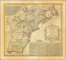
![[ Temperance Allegorical View ] Black Valley Railroad. Tickets Sold at all Liquor Shops. Accidents by Collisions are Entirely Avoided, as no up Trains are Run Over the Road.](https://storage.googleapis.com/raremaps/img/small/101469.jpg)