|
||

|

|
|

|
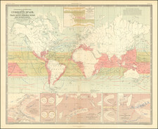
Rare Gold Rush era map of the World, illustrating the different sea routes to the Gold Regions of California.
With primary emphasis on the oceanic routes to the Gold Diggings, the map is also a fascinating early look at the early prospects for the transcontinental railroad. At the top center, the map includes a large inset, noting the route of the "Proposed Rail Road from St. Louis to the Bay of San Francisco Compiled from the Maps and Reports of Col. Fremont by W.L. Dearborn, Civil Engineer."
The inset map is drawn from an extremely rare and early pamphlet, illustrating a proposed route for the Transcontinental Railroad from St. Louis to San Francisco. The title of the pamphlet is Description of A Rail Road Route from St. Louis to San Francisco, Letters to P. P. F. Degrand, from W. L. Dearborn, Civil Engineer. 1849.
Dearborn's map received high marks from Carl Wheat in his Mapping of the American West, 1540-1857, p. 123 (1954), where he notes :
A far more important, and even prophetic, document was published by W. L. Dearborn, of Boston, whose "Map illustrative of the route of the proposed railroad from St. Louis to the Bay of San Francisco" (Wheat 78) accompanied his description of the route in letters written to P. P. F. Degrand. Save for the first stretch from St. Louis to the Kansas River and across to the Platte; save for a proposed use of South Pass, and save for the Sublette Cutoff portion, the Union Pacific and Central Pacific railroads were built almost precisely along Dearborn's proposed route.
Rarity
This would seem to be the first edition of the map.
David H. Burr studied law, passing the New York Bar Exam, and then surveying under Simeon DeWitt in New York. His first atlas was an atlas of New York State (1829), the second state atlas to be issued in the US (after Mills’ Atlas of South Carolina in 1826). In the 1830s, he served as the official topographer for the US Post Office, producing a series of rare and highly sought-after large-format state maps. He also created a map of the country’s postal routes, which features roads, canals, and railroads. Burr traveled to London to work with John Arrowsmith; together, they produced the American Atlas in 1839.
Upon his return to the States, Burr was appointed as a draftsman for the House of Representatives, where he worked until ca. 1841. He later worked for the Louisiana Survey and the Florida Survey. By 1850, he was back in Washington D. C., working on the census. In 1852, the Senate named Burr as the draftsman to compile maps from the Federal Surveys. In 1853, Burr traveled to San Francisco, perhaps as part of his work for the Senate. He was then named as the Surveyor General of Utah in 1855. However, he was unpopular there and returned to Washington D. C. by 1870. Burr is widely regarded as one of the most important names in the nineteenth-century American history of cartography.
![[Map of the World on a Globular Projection Exhibiting Particularly the Nautical Researches of Capn. James Cook, F.R.S. with all the Recent Discoveries to the Present Time carefully Drawn by A. Arrowsmith . . . ]](https://storage.googleapis.com/raremaps/img/small/94140.jpg)
![[Heightened in Gold] Nova Totius Terrarum Orbis Geographica Ac Hydrographica Tabula Autore N I Piscator . . . 1652](https://storage.googleapis.com/raremaps/img/small/82696.jpg)