


|
||

|

|
|

|
A Great Revolutionary War Rarity for New Jersey and Pennsylvania
Very rare Revolutionary War-era map of New Jersey, engraved by Croisey and published in Paris by the firm of François Perrier and Ambrose Verrier, in December of 1777 or early 1778.
While at first glance, the map appears to be a careful but straightforward copy of Bernard Ratzer's landmark map, The Province of New Jersey... (even the caption and credit to Faden are copied verbatim), Perrier & Verrier have significantly updated and improved upon Ratzer's work, most notably in the cartography in Pennsylvania, New York, and Connecticut. In these regions, the map shows far more detail than its English antecedent.
It is important to note that the core of the map is based on the 1777 first state of the Faden, lacking, for instance, the reference to the Battle of Monmouth ("June 28 1778 Freehold or Monmouth Courthouse"), "Englishtown", and "Nut Swamp", which are all added in the vicinity of Monmouth in the second state. Indeed, Monmouth is misspelled "Monmonth" in the present map.
The information in New York and Connecticut derives from Monetresor's A map of the Province of New York... (1777). In Pennsylvania, the map has been augmented with information from the Scull-Sayer & Bennet A Map of Pennsylvania... (1775).
The studied compilation of contemporary authoritative sources makes for a more complete and useful map than the original Faden, and the work involved in producing it could not have been cheap. In her 1996 survey of letters from continental map sellers to the firm of Jefferys and Faden, Mary Pedley raises the question of why this map was necessary when Perrier and Verrier could have simply resold the Faden maps they were purchasing directly from London:
Perrier and Verrier's willingness to invest in new copper plate and the costs of compilation and engraving reflect a demand in France for maps of North America and the war. The question that remains, however, is why did they not simply sell Faden's map and keep the profit? . . . It should be remembered that officers in the French army were expected to purchase their own maps and not to rely on a government office to supply them.
To our minds, this additional effort to consolidate information makes sense, as the French and Americans could not yet rely on the profusion of engraved maps of adjacent regions (Pennsylvania and New York) to which their British colleagues had easy access, though Le Rouge was also doing what he could to bridge the gap. Or perhaps the answer is even simpler: New Jersey was so important at this stage in the war because it lay in between New York and Philadelphia, and a map that covers the former should treat the latter with equal importance.
The earliest the map could have been produced is December of 1777, just after the first publication of the Faden. This is not beyond the realm of possibility; the French were extremely focused on the American war following the British defeat at the Battles of Saratoga in the Fall of 1777, leading up to the formal recognition of the United States in February of 1778. Furthermore, the Philadelphia-to-New York corridor had been the main focus of the war up to that point and would remain so through 1778. With so much action occurring in that area, a great French-produced map of the area was surely in high demand. The latest the map could have been published was probably in the spring of 1778. As Pedley notes, when Verrier and Perrier wrote to Faden in March of 1778, they had already received from him his map of New Jersey:
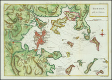
Julien's successors, Perrier and Verrier, wrote to Faden in March 1778 to ask for 'all the new maps you have published since your Jerseys', adding 'please do not send new maps which you could have copied from our French ones, since we would make nothing of them here . . .' They might have been thinking of Faden's map of Boston copied from Beaurain. Yet the irony of their remark was that they were about to sell their copy of Faden's map, The Province of New Jersey, Divided into East and West, Commonly Called the Jerseys.
Intended for the American Market?
Though the map was produced in France, the toponyms, title, and much of the captioning are rendered in English. This raises the intriguing possibility that the map was intended for export to the Continental Army, which was receiving considerable materiel aid from the French at the time - some estimates put the percentage of French-supplied arms used by the Americans in the Saratoga Campaign at up to 90%. This remains a fascinating area for future research.
Rarity
We find no copies having been previously offered for sale; with no copies, other than the present example, located in RBH, and none in the OldMaps database.
OCLC locates the following institutional examples: Library of Congress; NYPL; Clements; BPL; BL; Penn State; JCB; BnF.
![[Revolutionary War Plans of New York, Boston, Charleston, Delaware River to Philadelphia & Havana] Various Plans and Draughts of Cities, Towns, Harbours &c . . .](https://storage.googleapis.com/raremaps/img/small/83450.jpg)
![(American Revolution - Spanish Mapping) Mapa Geografico Que Comprehende La Nueva Inglaterra, Nueva York, Nueva Jersey, Pensilvania, Maryland y Parte de Virginia. [Geographic Map Encompassing New England, New York, New Jersey, Pennsylvania, Maryland, and Part of Virginia.]](https://storage.googleapis.com/raremaps/img/small/95136.jpg)