This item has been sold, but you can enter your email address to be notified if another example becomes available.


|
||

|

|
|

|
Stock# 72405
Description
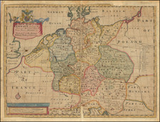
Antique engraved map of lower part of the Bishopric of Munster, published by Pierre Mortier in Amsterdam in the 1690s.
The map shows the area between Bremen and the Weser River in the northeast, the Dümmer See in the southeast, the Dutch border in the west, and the Dollard in the northwest.
Condition Description
Full original hand-color. Dampstain in the left blank margin, otherwise a VG+ example.
Pierre Mortier Biography
Pierre, or Pieter, Mortier (1661-1711) was a Dutch engraver, son of a French refugee. He was born in Leiden. In 1690 he was granted a privilege to publish French maps in Dutch lands. In 1693 he released the first and accompanying volume of the Neptune Francois. The third followed in 1700. His son, Cornelis (1699-1783), would partner with Johannes Covens I, creating one of the most important map publishing companies of the eighteenth century.
![[Ancient and Modern German Empires] Carte de la Germany et les Diferents Etats ou ses Peuples ont Porte Leurs Conquestes](https://storage.googleapis.com/raremaps/img/small/78195.jpg)