|
||

|

|
|

|
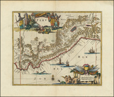
Exceedingly rare and historically important - An extraordinary example of Pedro Vicente Maldonado's Carta de la Provencia de Quito, one of the most impressive achievements of Enlightenment Era cartography and a landmark in the mapping of Latin America.
This monumental map, engraved on four large sheets, represents the first endeavor to create an accurate general map of what is now Ecuador and adjacent regions. It was the posthumously-published masterpiece of the Ecuador-born scientist, cartographer and explorer, Pedro Vicente Maldonado. Finely engraved and meticulously detailed, the map depicts the innumerable rivers, mountains, towns, roads and mines that lay across this vast and magnificent land. Published in 1750, in its accuracy and detail it far exceeded the quality of any other contemporary printed map of Latin America. Recent scholarship has revealed that the story behind its creation and publication is one of the most intriguing of any 18th Century work of cartography, and is revealing as to the larger interplay of science, commerce, politics and nationalism in Enlightenment Era Europe.
The map extends from Jaen on the Rio Maranon in what is not northern Peru, all the way northwards to Popayan (Colombia), and runs from the Pacific coast over the Andes to include the upper reaches of the Amazon Basin. The map includes important cities such as Quito, Guayaquil, Cuenca, Popayan and Esmeraldas. This vast region would have been one of the most challenging in the world to map, as it included thousands of square miles of coastal plains, volcanic peaks over 15,000 feet, and almost impenetrable jungles and malarial swamps.
Pedro Vicente Maldonado & the Story Behind the Map's Creation
Pedro Vicente Maldonado (1704-48) was an extraordinary figure of vast intellect and energies. Born into an influential Creole family in Riobamba, south of Quito, he was educated by the Jesuits. From 1722-24 he conducted a number of exploratory tours of regions of Ecuador seldom encountered by Europeans, creating his fist map in 1725. In 1724, he entered politics, and progressively rose from being the alcalde of Riobamba to being the Governor of Esmeraldas province. While he continued his mapping and scientific endeavors throughout, his political activities and influence gave him unprecedented access to cartographic source material in governmental and ecclesiastical archives. A number of public works projects were completed under his administration, most notably the road between Quito and Esmeraldas. His close connections to the Jesuits, who had made many excellent regional maps, also provided a wealth of information.
The catalyst for Maldonado's creation of the present map was his participation in the epic Spanish-French Equatorial Geodesic mission (1735-44). This endeavor was part of an effort to solve one of the most vexing questions of early Enlightenment science: whether the shape of the earth was oblate (flattened at the poles) or prolate (flattened near at the Equator). One of the critical factors in resolving the matter was measuring a length of a meridian arc of latitude at the Equator. The related Franco-Swedish Geodesic Expedition, which travelled to Lapland in 1736, proved that the earth's shape was oblate.
The mission was led by the French astronomers Charles Marie de La Condamine, Pierre Bouguer, Louis Godin and the Spanish geographers Jorge Juan y Santacilia and Antonio de Ulloa. Maldonado joined the mission in Ecuador, to lend it his unrivalled knowledge of the local terrain. The mission was groundbreaking as it was the first truly international scientific mission, idealistically placing scientific inquiry above parochial nationalism.
The mission's great cartographic achievement was to measure the arc of the meridian over three degrees of latitude, from the Equator to 3 degrees south. This resulted in the heart of Ecuador, the corridor from Quito to Cuenca, being mapped to exacting scientific standards by means of triangulated surveys. This ensured that the corridor was then one of the most accurately mapped areas in all of the Americas. Maldonado was thus able to integrate this critical cartography into his manuscript general map. While this map was a composite work, as opposed to being a systematic survey, overall it was amazingly accurate for its time, and its technical merit and scope, it compares favorably with far more famous contemporary surveys of New World subjects.
In 1744, Maldonado travelled to Spain, where he was received with great favor at Philip V's court. Highly impressed with Maldonado's cartography, the Spanish government agreed to sponsor the publication of his map. As will be discussed later, this was somewhat unusual, as the Spanish Crown had traditionally maintained a policy of cartographic secrecy, under which it was generally forbidden to publish detailed maps of Spanish colonial possessions, lest they be used to aid enemy powers. It would seem that, if only for a fleeting moment, the ethic of the Enlightenment, which held that the dissemination of scientific discoveries should trump censorship, would prevail.
It was decided that Maldonado's map should be published in Paris, which at the time was still the leading international center of map production. It was likely that no atelier in Spain had the ability to fulfill what was expected to be a technically challenging order. It was likely hoped that security concerns could be allayed by the fact that France was allied to Spain as part of the 'Bourbon Compact', and that appropriate measures would be taken to guard against the dissemination of information sensitive to national security.
Maldonado arrived in Paris in the early days of 1746, and met up with his former colleague and close friend from the geodesic mission, Condamine. Maldonado's manuscripts were entrusted to the atelier of Jean-Baptiste Bourguinon d'Anville, the leading French cartographer of the day. Maldonado remained in Paris long enough to work with Condamine, D'Anville and his associates to prepare the proof. However, Maldonado, intending to travel to various other cities in Europe, entrusted the oversight of the project to Condamine. Sadly, while on his travels, Maldonado died unexpectedly in London in November 1748.
An annotated proof of Maldonado's map survives at the Bibliotheque nationale de France. From that was seen that most of the numerous corrections, details, omissions and additions suggested by Maldonado were not enacted in the preparation of the final plates. Notably, Maldonado's request that locations of mines (economically sensitive information) be omitted from the final printed map was not honored. Nevertheless, D'Anville ensured that his master engraver, Guillaume Delahaye, burnished the plates to his exacting standards.
In the spring of 1750, as the four large plates that made up the map were still being engraved, the Spanish ambassador to Paris, who was the direct financier of the project, abruptly demanded that Condamine submit the finished plates, any pulls from the plates and any and all manuscript material used to prepare the map to Madrid. The precipitous nature of this demand, and the inclusion of all of the source material in the request, was somewhat unusual, and suggests that the Spanish likely had second thoughts about having such a detailed map of one of their heir prize possessions printed in a foreign country. Indeed, its seems as if the ambassador's demand was the first act in an attempt to bury the project, such that the resulting maps would remain exclusively in official Spanish hands.
Condamine, not wishing for Maldonado's great achievement to vanish into a secret Spanish archive, cleverly managed to delay honoring the Spanish ambassador's request long enough to engrave a second set of plates. The original set of plates features a dedication to the Spanish king, with no mention of the map being published in Paris. Condamine's second set of plates is identical, save that it omits the dedication to the Spanish monarch, in place of noting that the map was published by D'Anville in Paris. While the Spanish government duly received the plates and much of the source materials they requested, Condamine surreptitiously duplicated the map.
Very few pulls were ever made from either set of plates. While Condamine certainly retained a few copies of the first state maps, and while a handful more were retained by Spanish officialdom, it seems that not much more was ever done with the first set of plates. It is also clear that Condamine printed very few copies of the second state plates, intending that maps to be used for private academic use (and so as not to offend the Spanish). Notably, Condamine sent copies of the second state maps to Maldonado's family in Ecuador, and a set to the Royal Society in London.
Comdamine notably included a greatly reduced one-sheet version of Maldonado's map, the Carte de la Province de Quito au Pérou, in his own account of the Spanish-French Geodesic Mission, Journaux de route et Mémoires de Mr. De la Condamine (Paris, 1751).
The Greater Historical Context
Well into the 18th Century, the Spanish Crown imposed a policy of cartographic secrecy relating to the mapping of its New World possessions. Up to this time, while many impressive manuscript maps of various regions of Latin American had been made by Spanish officials and ecclesiastical authorities, very few of these ever made it into print. Indeed, the handful of original maps that were published were subject to censorship, such that many of the details of on the original manuscripts were removed, notably information that could be useful for military planning and operations (such as the (locations of fortifications, roads and mountain passes) or economically sensitive information (such as the locations of mines). Spanish officialdom was fearful of this information falling into the wrong hands.
The Spanish fears were not without foundation. Spain was frequently at war with Britain, and notably they were antagonists during the period from 1739 to 1748, and during this period Spain's American colonies and shipping were vulnerable to assaults by Britain's Royal Navy. Of note, Admiral Edward Vernon had attacked several Spanish ports in the Caribbean in 1740 and 1741. Commodore George Anson, during his Circumnavigation of the World (1740-4), had sailed up the coast of Chile, attacking Spanish merchant vessels, before crossing the Pacific to seize a Manila Galleon off of the Philippines. The last thing the Spanish wanted to do was to print accurate general maps of their colonial possessions, based on their own original intelligence, that could end up in London and in the hands of the British Admiralty.
However, the Spanish official policy of cartographic secrecy had profound negative ramifications for the Spanish Empire. The fact that many of their finest maps were never printed, or were not published in a timely fashion, ensured that vital cartographic information was often not available to officials in rather the colonies or in metropolitan Spain. The limitations on cartographic publishing retarded the development of Spain's printing industry, such that a sophisticated map printing culture did not develop in Madrid until the second half of the 18th Century. It also explains why it may not have been possible to print a detailed large-scale production in Spain, such as Maldonado's map, during this time.
Certainly, by the 1730s, some Spanish officials were aware of the negative effects of the cartographic secrecy policy, and indeed Madrid did grant permission for some important maps of its colonial domains to be published, although many of these were printed by the Jesuits in Rome. For example, Spanish officials permitted the Jesuits to publish an important map of Paraguay and the Rio de la Plata basin, Paraquariae Provinciae Soc. Jesu Cum Adiacentibus Novissima Descriptio (Rome, 1732). In 1746, Antonio de Villaseñor y Sánchez created a groundbreaking manuscript map of New Spain (Mexico) which was published in Rome in 1754, albeit with many of its original details deemed sensitive to military affairs omitted from the printed version. Likewise, Carolo Brentano's Provencia Quitensis (Rome, 1751), which embraced most of northern South America, was published omitting many sensitive details.
In addition to the practical benefits of printing maps, the traditional culture of secrecy increasingly ran against the growing tide of Enlightenment scientific inquiry, which stressed the imperative to disseminate and share scientific information with a global audience, for the common good of all mankind. However, just as religious orthodoxy ran against humanism during the Renaissance, the ethic of conservative nationalism uneasily coexisted, and often clashed, with the Enlightenment spirit. During this period it was not unusual for leading Spanish and French scientists to be the guests of honor at the Royal Society of London, or for British luminaries to be fêted in Paris. That is not to say that these intellectually liberal figures were not patriots, but merely that they were not completely in the thrall of the revanchist sentiments that traditionally prevailed between certain European states.
In spite of all the practical reasons why Spanish officials might wish to have Maldonado's map published, and accepting that it could not be printed in Spain, it is still somewhat remarkable that Madrid not only permitted, but paid for the publication of such a militarily and economically sensitive map to be overseen by foreigners in a foreign country. While France was an ally of Spain, French subjects could not have been reasonably expected to defend Spain's national interests in the same way as subjects of the Spanish Crown. While there would be further Franco-Spanish cartographic collaborations in the decades to come, in the late 1740s, the level and sensitivity of this geographic knowledge transfer from the Spanish Empire to France (and beyond) was unprecedented. Whichever Spanish official approved the plan to have the Maldonado map printed in Paris surely did not anticipate that how the venture would unfold. It would seem that the fact that the Spanish suddenly wanted all the materials relating to the map to be tendered to them, suggests that one of the officials in Madrid must have had (as it turned out, justified) reservations about this arrangement.
While the Spanish government received copies of the printed map and most of the supporting materials, they were betrayed by Condamine who printed the map so as to still contain the sensitive information that Maldonado had requested to be omitted. He also issued his own edition of the map, implicitly, if not explicitly, against the spirit of the arrangement with Madrid. The fact that Condamine forwarded one of the very few copies of the map to London, so that is could potentially end up in the hands of officials at Whitehall, would have be most galling. In essence, the case of the Maldonado map is a leading instance of where the traditional Spanish conservative systems were starting to erode under the pressure of the Enlightenment.
The States of Maldonado's Map
Their are two states of Maldonado map.
The second state of the map, with the added notation in the cartouche stating that the map was printed in Paris by D'Anville: "Por el S. D'Anville Geografo de S. Magt. Chrisma. de la Acad. Imp. De Petersburg / Sacada à la luz por D.C.D.L.C. / Paris M.DCCL.".
Rarity
We note examples in the Bibliotheque Nationale de France, National Library of Spain, British Library and Library of Congress, as well as the example we sold the John Carter Brown Library in 2014. https://www.raremaps.com/gallery/detail/37337
![[Oahu, Maui, Gallapagos, Cocos, etc.] Views Des Iles Sandwich et Autres Iles](https://storage.googleapis.com/raremaps/img/small/92400.jpg)
![[ Charleston, Boston, New York, St. Augustine, Bahamas, etc ] Particular Draughts of some of the Principal Towns and Harbours belonging to the English French and Spanish in America and the West Indies.](https://storage.googleapis.com/raremaps/img/small/102804.jpg)