


|
||

|

|
|

|
Stock# 72396
Description
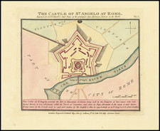
Rare and finely colored town plan of Castel Sant'Angelo, published in London by John Luffman.
Constructed by the Emperor Hadrian, the map notes that it was taken by the French in 1798.
The castle was initially commissioned by the Roman Emperor Hadrian as a mausoleum for himself and his family. The building was later used by the popes as a fortress and castle, and is now a museum. The structure was once the tallest building in Rome.
Rarity
The Luffman maps are very rare on the market. This is the first example of the map of Rome we have ever offered.
![Veduta di Piazza Navona sopra le ravine del Circo Agonale [View of the Piazza Navona above the Ruins of the Circus Agonalis; Circus of Domitian]](https://storage.googleapis.com/raremaps/img/small/93192.jpg)
![(The Roman Forum) Strata Viarum Urbis in Parte Regionis VIII. Sive Fori Romani [Streets of the City in Part of the Region VIII or the Roman Forum]](https://storage.googleapis.com/raremaps/img/small/88542.jpg)
![Veduta del Prospetto Principale della Colonna Antonina. [A Frontal View of the Column of Marcus Aurelius.]](https://storage.googleapis.com/raremaps/img/small/101718.jpg)
![Veduta della Fornice dé Consoli Dolabella, e Silano, investita dagli Archi Neroniani provenienti dal Condotto dell'Aqua Claudia [View of the Arch of the Consuls Dolabella and Silanus, Overwhelmed by Nero's Arches Originating from the Aqua Claudia Conduit.]](https://storage.googleapis.com/raremaps/img/small/92280.jpg)