|
||

|

|
|

|
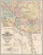
Fine large format map of Arizona, published in the same year as Arizona became a state.
The map locates American Indian Reservations, National Forests, Parks, and other public lands throughout the state. The reservations are highlighted in yellow and include the Papago, Apache, Navajo, Pima, Gila River, Salt River and others. Various national forests are noted, aptly colored green and include the Crook, Sitgreaves, Apache, Tusayan, Prescott, and Kaibab. The Grand Canyon National Part is highlighted in pink.
Includes small town plans of Phoenix and Tucson.
The map also notes railroads, mines, rivers, gulches, mountain ranges, etc.
The General Land Office (GLO) refers to the independent agency in the United States that was in charge of public domain lands. Created in 1812, it assumed the responsibilities for public domain lands from the United States Department of the Treasury. The Treasury had overseen the survey of the Northwest Territory, but as more area was added to the United States, a new agency was necessary to survey the new lands.
Eventually, the GLO would be responsible for the surveying, platting, and sale of the majority of the land west of the Mississippi, with the exception of Texas. When the Secretary of the Interior was created in 1849, the GLO was placed under its authority. Until the creation of the Forest Service in 1905, the GLO also managed forest lands that had been removed from public domain. In additional to managing the fees and sales of land, the GLO produced maps and plans of the areas and plots they surveyed. In 1946, the GLO merged with the United States Grazing Service to become the Bureau of Land Management.

![[ Early Western Automobile Road Map ] Goodrich Road Map of Arizona - Colorado - New Mexico - Utah](https://storage.googleapis.com/raremaps/img/small/101927.jpg)