|
||

|

|
|

|
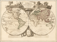
Scarce antique engraved double-hemisphere map of the world by Cornelis Wytfliet, reduced from Rumold Mercator's map of 1587.
Though Wytfliet's famous work, Descriptionis Ptolemaicae Augmentum, sive Occidentis Notitia, focused on the New World, it opened with this map of the whole world, supported at the base by the figure of Atlas.
The map was issued in 1597, just as important cartographic advancements were resulting from the voyages of Linschoten, Barentsz, Houtman, and others. Despite this, it relies on earlier information, namely the Mercator world referenced earlier. The New World maps within the same work were in part derived from the 1592 Plancius world.
In the Arctic, Wytfliet follows the Mercator model, with four main islands around the Pole, Nova Zemblaya is merged with one of the islands, an error that would be corrected by Barentsz.
The map includes a vast Terra Australis stretching across the entire southern quarter.
Cornelius de Wytfliet (ca.1550-ca. 1597) was a Flemish cartographer most famous for his Descriptionis Ptolemaicae Augmentum. The work was published in Louvain, Belgium, and had nineteen maps of the Americas.
![Eastern Hemisphere [with] Western Hemisphere](https://storage.googleapis.com/raremaps/img/small/92642.jpg)
![[ Game Board World Map -- Gulf of Korea named ] Walker's Geographical Pastime Exhibiting a Complete Voyage Round the World in Two Hemisphere with Tetotum, Pillars & Counters, for Playing This Highly Interesting Game.](https://storage.googleapis.com/raremaps/img/small/102691.jpg)