|
||

|

|
|

|
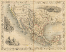
One of the Earliest Obtainable Regional Maps of Mexico
Important early map of Mexico, from Cornelis Wytfliet's Descriptionis Ptolemaicae Augmentum, the first atlas to focus on the mapping of the New World.
Wytfliet's map marks a dramatic step forward in the depiction of Mexico, dramatically reworking the earlier depictions of mapmakers such as Gastaldi, Ruscelli and Ortelius. The map stretches from what is now the American Southwest across to the Florida coast in the north, encompassing much of Texas. It continues south to Guatemala.
Settlements, including Acapulco and Veracruz, are shown in abundance. The largest of these is Mexico City, arrayed on a lake in the center of the colony. Several other lakes are also shown, as are river systems. The Rio Grande is here called the R. de Palmas; a year after this map was made it would receive its modern moniker of Grande.
A handsome title cartouche is in the lower left corner, adorned with birds and flowers.
A fine map, it improves on the detail and shape of earlier maps by Giacomo Gastaldi (1548) and Girolamo Ruscelli (1561). It shows considerably more area than Ortelius’ map showing part of southwest New Spain (1579), or his three other related maps (Florida, Culicana, Guastecan—all 1579-84). Sources for this map included the Gastaldi and the Ruscelli, as well as Plancius’ 1592 world map.
Early Spanish exploration and the mapping of New Spain
This map holds historical significance as it is an early cartographic representation of the Spanish colony of New Spain. The sixteenth century was a time of rapid expansion and urbanization across the territory, with Spanish colonizers and explorers seeking to establish outposts for the purpose of conquering land and evangelizing indigenous peoples.
Spanish navigators initially contacted Mexico in 1518; they had already landed in Central America and had reached the Pacific in 1513. The first Spanish settlement in what is today Mexico was established following the invasion by conquistador Hernán Cortés in early 1519. After spending several months in the Yucatan, Cortés sought to expand his reach. He established Veracruz and then burned his ships to prepare his men for an overland expedition.
He marched on Tenochtitlan, the capital of the Aztec Empire, and eventually took it, alongside indigenous allies. Cortés then oversaw the construction of a nascent Mexico City and King Charles I named him governor of the colony, New Spain. After a fall from grace, in the late 1530s, Cortés explored northern Mexico and Baja California.
The northern parts of this map reflect the explorations of Cabeza de Vaca, Moscoso, and Piñeda. Alonso Álvarez de Piñeda (1494-1520) was the first European to create a map of the Texas Gulf Coast. Indeed, his maps are some of the only documents historians have to study his life. He is credited with encountering and naming Corpus Christi, Texas, and explored the area that is now Brownsville, Texas. His voyage, which resulted in his death at the age of 25, proved that the Gulf of Mexico did not house a viable route to the Pacific Ocean.
Álvar Nuñez Cabeza de Vaca (ca. 1490-ca. 1557) was known for being among the first Europeans to explore the interior of what is now Texas after he and his crew shipwrecked on the Texas coast in 1528. While Cabeza de Vaca did not acquire any new territory for Spain, he and his companions spread rumors of unfound riches in North America which prompted a wave of Spanish exploration of the continent in the following years.
Luis de Moscoso de Alvarado (1550-1551) was one of the most prominent explorers sent in search of these fabled riches by the Spanish government. While the initial goal of Moscoso and his companions was to find riches, Moscoso decided to focus on finding an overland route from the Mississippi River to Mexico after Hernando de Soto, the expedition leader, died. In the process of finding a route to Mexico, Moscoso became one of the first Europeans to explore East Texas before sailing to Mexico along the Mississippi River and Gulf of Mexico.
Cornelius de Wytfliet (ca.1550-ca. 1597) was a Flemish cartographer most famous for his Descriptionis Ptolemaicae Augmentum. The work was published in Louvain, Belgium, and had nineteen maps of the Americas.

![Mexican Painting. 3776 Codex Vaticanus page 74. Aglio 3rd Vol. called the Little Vatican MS. [on sheet with] Quetzalcoatl Crucified Codex Borgianus...](https://storage.googleapis.com/raremaps/img/small/102318.jpg)