|
||

|

|
|

|
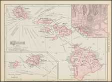
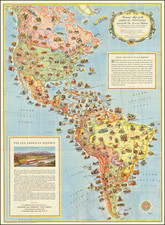
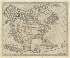
Scarce map of North America, with two large inset maps, one depicting the NW Coast of America and one depciting the Sandwich Isles. The map includes some of the best ephemeral cartography of the early 19th Century, including a marvelous depiction of the NW Coast, based upon Vancouver's voyages, 54-40 or fight Canada-Oregan Territorial border, excellent post Lewis & Clark cartography, two Salt Lakes (Timanagos & Teguayo), mythical rivers connecting Salt Lake to San Francisco Bay, double wide Arkansas Territory, massive Oregan Territory, the Spanish Trail from Sabine to Santa Fe past Salt Lake to just north of San Francisco, and a host of other details. One of the best features of the map are the many Hudson's Bay Company Houses depicted, including Nelson Hs, Acton Hs, Chesterfield Hs, Manchester Hs, Buckingham Hs, Hudsons Hs, Cumberland Hs, Pine Hs, Chatam Hs, Grands Hs, Marlborough Hs, Henly Hs, Red Lake Hs, Brunswick Hs, Abittibbi Hs, Osnaburg Hs, Gloucester Hs, etc. A number of early forts are also shown in Canada and the Northwest. This edition states that it is revised to 1823, but several annotations are dated as late as 1824. A scarce map which apparently appeared in early editions of Steiler's Hand Atlas.
Christian Gottlieb Reichard (1758-1837) was a German cartographer. Reichard studied law in Leipzig and found work as a town clerk in Bad Lobenstein. He had great personal interest in geography, history, and cartography, hobbies which gained him more renown than law. However, even after he began making maps, he continued working his clerk job, which gave him the financial stability to support his family.
Reichard is best known for his work on his Atlas des Ganzen Erdkreises in der Central Projection (Atlas of the Whole World in the Central Projection) in 1803 and the Orbis terrarum antiquus (Atlas of the Ancient World) of 1824. He is also likely the first published cartographer to adopt the Albers conic projection, in his map Die Vereinigten Staaten von Nord-America, nach den sichersten Bestimmungen, neuesten Nachrichten und Charten, in der Alber’schen Projection entworfen, (The United States of North America, after the safest regulations, latest news and charts, designed in the Alberian projection), where he references the Albers projection by name.
Reichard’s work was known by his contemporaries as highly accurate, and in fact this descriptor still holds up today. This accuracy, along with his skill, made him very publishable, and he worked on a number of atlases with other cartographers, such as Steiler’s Handatlas. Reichard’s style is simple but includes great detail, making his maps both recognizable at a glance and engaging upon deeper study.