


|
||

|

|
|

|
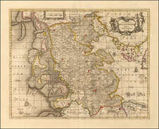
This is an exquisite, old color example of Jaillot's map, produced and published in Paris, exemplifying the finesse of Jaillot's cartographic craftsmanship.
This unique map showcases the regions of Upper Saxony, a historically significant area in northeastern Germany. The map's central focus is the cities of Leipzig and Dresden, nestled within the Marquisat of Meissen. Leipzig and Dresden, as prominent cities of the period, form the nexus of this cartographical masterpiece, reflecting their historical importance and their vibrant cultures.
In addition to Leipzig and Dresden, several other important cities find representation on this map. These include Gotha, a city known for its rich architectural and cultural heritage; Erfurt, with its medieval influences and the iconic Erfurt Cathedral; and Halle, renowned for its Baroque-style market square and the 16th-century Moritzburg Castle. These cities' presence on the map underscores their significance in the region during the late 17th century.
Jaillot's map, adorned with vibrant old colors and meticulous detail, provides a fascinating glimpse into the geography of Upper Saxony as it was in 1692. It captures the region's intricate blend of political jurisdictions, including the Duchy and Electorate of Saxony, the Marquisates of Midnie and Lusace, and the Landgraviate of Thuringia. Further, it includes other significant territories such as Brandenburg and Pomerania.
In essence, Jaillot's map of Upper Saxony is not just an artful and accurate representation of the region's geography in the late 17th century; it's a testament to the era's thriving urban centers and complex political landscapes.
Alexis-Hubert Jaillot (ca. 1632-1712) was one of the most important French cartographers of the seventeenth century. Jaillot traveled to Paris with his brother, Simon, in 1657, hoping to take advantage of Louis XIV's call to the artists and scientists of France to settle and work in Paris. Originally a sculptor, he married the daughter of Nicholas Berey, Jeanne Berey, in 1664, and went into partnership with Nicholas Sanson's sons. Beginning in 1669, he re-engraved and often enlarged many of Sanson's maps, filling in the gap left by the destruction of the Blaeu's printing establishment in 1672.
![Holsatiae Descriptio [with] Rugiae Usedomiae et Iulinae Wandalicarum insularum Vera descrtiptio 1584](https://storage.googleapis.com/raremaps/img/small/83746.jpg)
