|
||

|

|
|

|
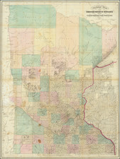
Scarce early map of Minnesota map, published by Silas Chapman in 1856.
A comprehensive study of the states of these early Minnesota maps has not been completed, however, we note some differences between this state and others we have handled. This map includes a crude depiction of Lake Minnetonka to the west of Fort Snelling, other examples of the 1856 do not. Evidently, some editions show a Sioux Reservation in Goodhue and Wabasha Counties and Houston County.
1856 was a busy year for Chapman, as he also offered his New Section Map of Minnesota for the first time that year. That map was substantially more accurate, leaning on the recent official surveys that were being completed at the time.
Chapman produced several pocket maps of Minnesota, Wisconsin, and Iowa. His maps were also reproduced later by other publishers.
![The Minnesota Handbook, for 1856-7 [with] Minnesota Published by J.H. Colton & Co... 1857.](https://storage.googleapis.com/raremaps/img/small/69729.jpg)
![Diagram showing ceded and reserved Chippewa lands in Minnesota [with:] In the Supreme Court of the United States. October Term, 1912.](https://storage.googleapis.com/raremaps/img/small/93674.jpg)