


|
||

|

|
|

|
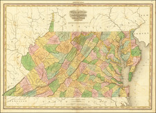
Rare separately published example of the first edition of Tanner's Map of Virginia, Maryland, and Delaware, from Tanner's monumental American Atlas, without question the finest of all 19th Century American commercial atlases.
The map is hand-colored by counties and includes towns, roads, rivers, mountains, and mileage between major towns along the primary roads.
The present map was separately issued, but is more commonly found bound into Tanner's landmark American Atlas.
The issuance of this atlas represented a landmark in American cartographic publishing history, marking the first time a large-format American published atlas employed the engraving quality of its European competitors. Tanner conceived the atlas as the first large format systematic mapping of the US and began the project with a prospectus issued in 1818 and thereafter began issuing the maps in subscription format in folio groups beginning in 1819. The completed atlas in bound form was issued for the first time in 1823, and is perhaps the most sought after of all American atlases.
States of the Map
The map was issued in a number of editions, beginning in 1820. The present example can be identified as the earliest state, as it lacks the name "American Atlas" at the top center.
The map would be updated and re-issued by Tanner into the 1840s.
![Preliminary Chart of the Potomac River (in four sheets) Sheet No. 1 From Entrance to Piney Point [with] Sheet No. 2 From Piney Point to Lower Cedar Point [with] Sheet No. 3 From Lower Cedar Point to Indian Head [with] Sheet No. 4 From indian Head to Little Falls Bridge](https://storage.googleapis.com/raremaps/img/small/88214.jpg)
![[ Carolinas & Georgia ] Virginiae Partis australis, et Floridae partis orientalis, interjacentiumqus regionum Nova Descriptio](https://storage.googleapis.com/raremaps/img/small/81554.jpg)
![[ 20 Historical Border Survey Maps Tracking The History of Pennsylvania's Borders ]](https://storage.googleapis.com/raremaps/img/small/96836.jpg)