|
||

|

|
|

|
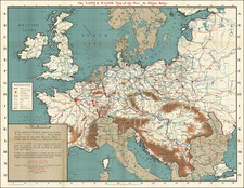
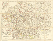
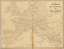
Striking 4 sheet map of Europe, published to illustrate the changed boundaries following the Congress of Vienna.
The Congress of Vienna of 1814–1815 was one of the most important international diplomatic conferences in European history, reconstituting the European political order after the downfall of the French Emperor Napoleon I. It was a meeting of ambassadors of European states chaired by Austrian statesman Klemens von Metternich, and held in Vienna from November 1814 to June 1815.
The objective of Congress was to provide a long-term peace plan for Europe by settling critical issues arising from the French Revolutionary Wars and the Napoleonic Wars. The goal was not simply to restore old boundaries but to resize the main powers so they could balance each other and remain at peace. More fundamentally, the conservative leaders of the Congress sought to restrain or eliminate the republicanism and revolution which had upended the constitutional order of the European ancient régime, and which continued to threaten it. In the settlement, France lost all its recent conquests, while Prussia, Austria and Russia made major territorial gains. Prussia added smaller German states in the west, Swedish Pomerania, and 60% of the Kingdom of Saxony; Austria gained Venice and much of northern Italy. Russia gained parts of Poland. It ratified the new Kingdom of the Netherlands which had been created just months before from the formerly Austrian territory that in 1830 became Belgium.
John Thomson (1777-ca. 1840) was a commercial map publisher active in Edinburgh. He specialized in guide books and atlases and is primarily known for his Atlas of Scotland (1832) and the New General Atlas, first published in 1817 and reissued for the next quarter century. The New General Atlas was a commercial success—it was also published in Dublin and London—and it compiled existing geographic knowledge in compelling ways for a wide audience.
His Atlas of Scotland introduced new geographic information and was the first large-scale atlas of Scotland to be organized by county. It provided the most-accurate view of Scotland available before the Clearances. Work on the atlas began in 1820 and led to Thomson’s bankruptcy in 1830 due to the high costs of gathering the latest surveys and reviewing the required materials. Despite the publication of the atlas, Thomson declared bankruptcy again in 1835.