


|
||

|

|
|

|
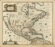
Putting the World in Biblical Context—with Late Example of California as an Island!
Striking example of this (very) late edition of Mortier's map of the world, showing California as an island.
The map is after Mortier’s ca. 1700 map from an unknown Biblical work. This example, engraved by a Mademoiselle Glot, was printed as part of Jacques Desray’s Nouvel atlas de la Bible (1809).
California is shown an island. Just to the north is the mythic Strait of Anian, which allows for a Northwest Passage via Baffin or Hudson’s Bay. A truncated eastern Russia also suggests a Northeast Passage, although the shores of North Pacific chimeras, like Terre de la Compagnie, might make its Pacific entrance difficult to navigate.
The Great Lakes are shown as a collection of waterways and are merely labeled as Mer Douce, or the Sweet Sea. A huge, unnamed lake in central North America flows to the Gulf of California via a North River.
Initially completed before the large-scale European exploration of the Pacific in the late-eighteenth century, New Zealand is shown as a small stretch of coast. Both this and the outline of part of Van Diemen’s Land (Tasmania) come from Tasman’s first voyage of 1642-3. New Holland (Australia) is incomplete, with toponyms coming from early-seventeenth century Dutch encounters. Australia seemingly connects to New Guinea, or is separated by only the narrowest of straits.
Extra details are inserted into the exaggerated spaces of the Arctic, a result of the Mercator projection’s stretching of polar areas. Here there are five spheres that illustrating various geographic and astronomical theories via a Biblical lens.
At the far left is a Biblically-inflected diagram of the division of day and night. Next is a visualization of the world with no water (again, with Biblical references), in which there are southern lands in the South Pacific. In the center is a geocentric model of the universe showing the phases of the moon. Finally, at the right is a double-hemisphere map of the world. This map, in contrast to the larger one, includes huge southern continents in addition to New Holland.
The popular misconception of California as an island can be found on European maps from the sixteenth through the eighteenth centuries. From its first portrayal on a printed map by Diego Gutiérrez, in 1562, California was shown as part of North America by mapmakers, including Gerardus Mercator and Abraham Ortelius. In the 1620s, however, it began to appear as an island in several sources. While most of these show the equivalent of the modern state of California separated from the continent, others, like a manuscript chart by Joao Teixeira Albernaz I (ca. 1632) now in the collection of the National Library of Brasil shows the entire western half of North Americas as an island.
The myth of California as an island was most likely the result of the travel account of Sebastian Vizcaino, who had been sent north up the shore of California in 1602. A Carmelite friar, Fray Antonio de la Ascensión, accompanied him. Ascension described the land as an island and around 1620 sketched maps to that effect. Normally, this information would have been reviewed and locked in the Spanish repository, the Casa de la Contratación. However, the manuscript maps were intercepted in the Atlantic by the Dutch, who took them to Amsterdam where they began to circulate. Ascensión also published descriptions of the insular geography in Juan Torquemada’s Monarquia Indiana (1613) (with the island details curtailed somewhat) and in his own Relación breve of ca. 1620.
The first known maps to show California as an island were on the title pages of Antonio de Herrera’s Descripción de las Indias Occidentales (1622) and Jacob le Maire's Spieghel Der Australische Navigatie (1622). Two early examples of larger maps are those by Abraham Goos (1624) and another by Henry Briggs, which was included in Samuel Purchas’ Hakluytus Posthumus or Purchas his Pilgrimes (1625). In addition to Briggs and Goos, prominent practitioners like Jan Jansson and Nicolas Sanson adopted the new island and the practice became commonplace. John Speed’s map (1626-7), based on Briggs’ work, is well known for being one of the first to depict an insular California.
The island of California became a fixture on mid- and late-seventeenth century maps. The island suggested possible links to the Northwest Passage, with rivers in the North American interior supposedly connecting to the sea between California and the mainland. Furthermore, Francis Drake had landed in northern California on his circumnavigation (1577-80) and an insular California suggested that Spanish power in the area could be questioned.
Not everyone was convinced, however. Father Eusebio Kino, after extensive travels in what is now California, Arizona, and northern Mexico concluded that the island was actually a peninsula and published a map refuting the claim (Paris, 1705). Another skeptic was Guillaume De L’Isle. In 1700, De L’Isle discussed “whether California is an Island or a part of the continent” with J. D. Cassini; the letter was published in 1715. After reviewing all the literature available to him in Paris, De L’Isle concluded that the evidence supporting an insular California was not trustworthy. He also cited more recent explorations by the Jesuits (including Kino) that disproved the island theory. Later, in his map of 1722 (Carte d’Amerique dressee pour l’usage du Roy), De L’Isle would abandon the island theory entirely.
Despite Kino’s and De L’Isle’s work, California as an island remained common on maps until the mid-eighteenth century. De L’Isle’s son-in-law, Philippe Buache, for example, remained an adherent of the island depiction for some time. Another believer was Herman Moll, who reported that California was unequivocally an island, for he had had sailors in his offices that claimed to have circumnavigated it. In the face of such skepticism, the King of Spain, Ferdinand VII, had to issue a decree in 1747 proclaiming California to be a peninsula connected to North America; the geographic chimera, no matter how appealing, was not to be suffered any longer, although a few final maps were printed with the lingering island.
Pierre, or Pieter, Mortier (1661-1711) was a Dutch engraver, son of a French refugee. He was born in Leiden. In 1690 he was granted a privilege to publish French maps in Dutch lands. In 1693 he released the first and accompanying volume of the Neptune Francois. The third followed in 1700. His son, Cornelis (1699-1783), would partner with Johannes Covens I, creating one of the most important map publishing companies of the eighteenth century.

![Newsmap. Monday, June 29, 1942 [on verso:] Our Fighting Ships](https://storage.googleapis.com/raremaps/img/small/93346.jpg)