|
||

|

|
|

|
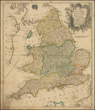
Le Clerc's Rare Map of England Annotated in a Contemporary Hand
Fine example of first state of Le Clerc's rare map of England and Wales, based upon the earlier maps of Christopher Saxton and Jan Baptiste Vrient.
This very handsome work is based on Christopher Saxton's pioneering survey of England and Wales, and is one of the rarest maps of England
Jean Le Clerc was an engraver, bookseller and publisher who spent a number of years in Tours before moving to Paris sometime around 1594.
While based upon Saxton and crediting Saxton at the right side of the map, Le-Clerc has copied the Vrients-Saxton map of 1603. It replicates Saxton's map of England of 1579 in a beautifully engraved style. A naval battle is taking place off the Cornish coast.
The map is often found in poor condition but here is in fine condition.
Christopher Saxton
In the 1570s, Lord Burghley, the chief minister to Queen Elizabeth I, commissioned Christopher Saxton to conduct the first systematic survey of each of the counties of England and Wales. The result was the publication of Saxton's magnificent Atlas of England and Wales (1579), which included his groundbreaking national map Anglia. It took some time for the leading Continental map publishers to recognize the superior nature of Saxton's work.
Jean Le Clerc was an engraver, bookseller and publisher in Paris and Tours.
Le Clerc was baptized on August 16, 1560 in Paris, with the engraver François Desprez (1530–1587) and the painter Jérôme Bollery (1532–1592) as his godfathers. He came from a family of printers and publishers - Jean's younger brother David Le Clerc (1561–1613) and Jean's own son Jean Le Clerc V were both book printers and publishers.
He had proved himself by 1587, at which date he was living and working on Rue Chartière in Paris. For religous reasons, as a Huguenot he fled Paris in 1588 and spent a year elsewhere in France. From 1590 to 1594 he took refuge in Tours, where he worked with the publisher and cartographer Maurice Bouguereau (15??–1596), who created Le Theatre Francoys, the first atlas of France. Le Clerc later worked at several different addresses in Paris - on Rue Saint-Jean-de-Latran until 1610 and then on Rue Saint-Jacques until 1621/24.
Jean Le Clerc's publications included portraits, maps, contemporary news events and other engravings by Jacques Granthomme (1560–1613), Pierre Firens (1580–1636) and Léonard Gaultier (1561–1635). He collaborated with the Dutch printmaker Thomas de Leu (1560–1612) to produce a collection of 179 biblical scenes, allegories, calendar pages and other works, probably published in 1606. They both produced engravings for it themselves as well as using works by Justus Sadeler (1580–1620), Isaac Briot (1585–1670) and Nicolas Briot (1579–1646).
On December 20, 1619 Le Clerc was granted a six-year royal concession to "engrave maps of the provinces of France and portraits of patriarchs and princes of the Hebrew people, with a chronological history". In 1620 he published his Le Théâtre géographique du Royaume de France, including newer plates as well as reworked plates from Bouguereau's work. The new plates were produced by artists such as Jean Fayen (1530–1616), Jodocus Hondius (1563–1612), Salomon Rogiers (1592–1640) and Hugues Picart (1587–1664). It went through several editions and Jean Le Clerc V continued to reissue it after his father's death.

![[England, Scotland & Wales]. Parte Settentrionale del Regno d'Inghilterra . . . (with) Parte Meridionale del Regno d'Inghilterra . . .](https://storage.googleapis.com/raremaps/img/small/89516.jpg)