


|
||

|

|
|

|
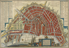
A decorative view of Amsterdam, showing fortified walls, windmills, buildings, and harbor, with over 100 ships at anchor along with barges on the Amstel. Drawn at the start of Amsterdam's Golden Age, the work portrays the city as a force to be reckoned with. The plan shows two coats of arms including the famous three St. Andrew's Crosses though on a red, not black background.
The map is shown from the perspective from present-day Amsterdam Noord, looking south. This creates an imposing and nearly symmetric plan of the city, focused on Amsterdam's harbor housing fleets of trade and warships. In the west (right of the image), Amsterdam extends to the edge of the outer ramparts and the Singelgracht canal. In the east, the city is slightly stunted and only reaches approximately to the Nieuwe Herengracht canal and inner ramparts, now overbuilt. Outer fortifications are shown extending around the city, though they would not be completed until 1660 when the Singelgracht was finished and Amsterdam grew into its famous crescent shape.
This map preserves an attractive view of 17th century Amsterdam as it was expanding to fill its position as a world power. The distinctive symmetry of the city, still visible in its modern layout, is beautifully presented.
Mathaus Merian (1593-1650) was the father of engraver Matthäus the Younger, and of the painter, engraver, and naturalist Maria Sibylla Merian. He was born in Basel, Switzerland and trained in engraving in Zurich. After a time in Nancy, Paris and Strasbourg, he settled in Frankfurt. While there, he worked for Johann Theodor de Bry, the publisher and son of the travel writer. In 1617, he married Maria Magdalena de Bry, Johann Theodor’s daughter. In 1623, Merian took over the de Bry publishing house upon the death of his father-in-law. Merian’s best known works are detailed town views which, due to their accuracy and artistry, form a valuable record of European urban life in the first half of the sixteenth century
![[Amsterdam] Amsteldam, Capitale de la Hollande](https://storage.googleapis.com/raremaps/img/small/76323.jpg)
![[Amsterdam] Amstelredamum, Nobile Inferioris Germaniae Oppidum](https://storage.googleapis.com/raremaps/img/small/96920.jpg)
![[ Amsterdam ] Accurater Grundris und Prospect der Weltberuhmten Hollandischen Haupt und Handels-Stadt Amsterdam . . . 1727](https://storage.googleapis.com/raremaps/img/small/89309.jpg)
![[Amsterdam] Plan Tres Exact De La Fameuse Ville Marchande D'Amsterdam](https://storage.googleapis.com/raremaps/img/small/80445.jpg)