


|
||

|

|
|

|
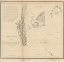
Fine large format chart of San Diego Bay, published by the British Admiralty.
The map is revised to 1925, with smaller hand drawn corrections to 1929.
The map presents a detailed chart of San Diego Bay, including topographical features, soundings, light houses, beacons, navigational details, etc.
The street plans for a number of communities around the bay are shown, including La Playa, Roseville, Old Town, San Diego, Coronado and National City. Other smaller communities are also shown.
In San Diego, the customs house, post office, wireless masts, Naval Hospital, and a pier under construction are highlighted. Around the Bay, MCRD is shown (Marine Barracks), as is the US Naval Training Center (including a club house), The US Naval Fuel Depot, Quarantine site, Cabrillo Monument, etc.
The US Naval Air Station on North Island is shown, along with the Ferry landing on Coronado.
US Naval Air Station on North Island
In 1914, North Island was the site where then unknown aircraft builder, Glenn Martin, took off and demonstrated his pusher aircraft over the island with a flight that included the first parachute jump in the San Diego area. The jump was made by a ninety-pound civilian woman named Tiny Broadwick. Other aviation milestones originating at North Island included the first seaplane flight in 1911, the first mid-air refueling and the first non-stop transcontinental flight, both in 1923.
Before the Air Station was commissioned, Glenn Curtiss also trained the first group of Japanese aviators at his flying school on the Island. Among them was a Lieutenant C. Yamada would later become infamous as the head of Japan's Naval aviation forces in World War II.
In 1917, Congress appropriated the land and two airfields were commissioned on its sandy flats. The Navy started with a tent-covered compound known as "Camp Trouble". The Navy shared the island with the Army Signal Corps' Rockwell Field until 1937, when the Army left and the Navy expanded its operations to cover the whole island.
One of history's most famous aviation feats was the flight of Charles A. Lindbergh from New York to Paris in May 1927. His aircraft, The Spirit of St. Louis, was built in San Diego, and his flight originated at North Island on May 9, 1927, when he began the first leg of his transatlantic journey.
Forefathers of today's "Blue Angels", the three-plane "Sea Hawks" of VF-6B, the "Felix the Cat" squadron, were thrilling audiences with flight demonstrations as early as 1928. They demonstrated the training skills of Navy fighter and bomber pilots and on many occasions, and even flew their aircraft in formation with the wings tethered together.
The British Admiralty has produced nautical charts since 1795 under the auspices of the United Kingdom Hydrographic Office (HO). Its main task was to provide the Royal Navy with navigational products and service, but since 1821 it has also sold charts to the public.
In 1795, King George III appointed Alexander Dalrymple, a pedantic geographer, to consolidate, catalogue, and improve the Royal Navy’s charts. He produced the first chart as the Hydrographer to the Admiralty in 1802. Dalrymple, known for his sticky personality, served until his death in 1808, when he was succeeded by Captain Thomas Hurd. The HO has been run by naval officers ever since.
Hurd professionalized the office and increased its efficiency. He was succeeded by the Arctic explorer Captain William Parry in 1823. By 1825, the HO was offering over seven hundred charts and views for sale. Under Parry, the HO also began to participate in exploratory expeditions. The first was a joint French-Spanish-British trip to the South Atlantic, a voyage organized in part by the Royal Society of London.
In 1829, Rear-Admiral Sir Francis Beaufort was appointed Hydrographer Royal. Under his management, the HO introduced the wind force scale named for him, as well as began issuing official tide tables (1833). It was under Beaufort that HMS Beagle completed several surveying missions, including its most famous voyage commanded by Captain FitzRoy with Charles Darwin onboard. When Beaufort retired in 1855, the HO had nearly two thousand charts in its catalog.
Later in the nineteenth century, the HO supported the Challenger expedition, which is credited with helping to found the discipline of oceanography. The HO participated in the International Meridian Conference which decided on the Greenwich Meridian as the Prime Meridian. Regulation and standardization of oceanic and navigational measures continued into the twentieth century, with the HO participating at the first International Hydrographic Organization meeting in 1921.
During World War II, the HO chart making facility moved to Taunton, the first purpose-built building it ever inhabited. In 1953, the first purpose-built survey ship went to sea, the HMS Vidal. Today, there is an entire class of survey vessels that make up the Royal Navy’s Hydrographic Squadron. The HO began to computerize their charts in the late 1960s and early 1970s. In 1968, the compilation staff also came to Taunton, and the HO continues to work from there today.
![[Historical Map of Julian, California]](https://storage.googleapis.com/raremaps/img/small/94157.jpg)
![[ San Diego County / Julian Mining District ] Sixth Annual Report of the State Mineralogist. Part I for the year ending June 1st 1886.](https://storage.googleapis.com/raremaps/img/small/101709.jpg)