


|
||

|

|
|

|
A New Map of the Kingdoms of Spain and Portugal with Their Principal Divisions is a detailed antique map of the Iberian Peninsula on the cusp of the Napoleonic Wars, dated 1794. Published in London by Laurie & Whittle, this map stands as an invaluable historical record, revealing the geopolitical landscape of Spain and Portugal just prior to Napoleon's peace treaty with Spain in 1795.
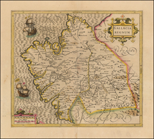
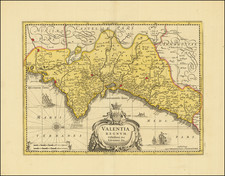
This map depicts the specific division of Spain into provinces under the Crown of Castille and the Crown of Aragon. Castille's provinces, numbering eleven, include Old Castille, New Castille, Navarra, Biscay, Asturias, Galicia, Leon, Estremadura, Andalusia, Granada, and Murcia. Meanwhile, Aragon's domain includes Aragon proper, Catalonia, and Valencia, which further encapsulates the Kingdom of Majorca and the Balearic Islands—Majorca, Minorca, and Ivica.
This cartographic portrayal offers significant insights into the historical statehood of Spain, conveying the then-contemporary administrative and territorial divisions. These divisions, crucial to understanding the socio-political dynamics of late 18th-century Spain, would soon undergo significant transformations in the turbulent period that followed.
The inclusion of the Balearic Islands underscores their strategic importance in maritime affairs and trade, further adding a dimension of geopolitical significance to this map. This feature, combined with the map's overall meticulous detailing, makes it a noteworthy artifact from a momentous period in European history.
A New Map of the Kingdoms of Spain and Portugal with Their Principal Divisions thus represents a rich tapestry of geographical knowledge, historical relevance, and cartographic precision. Its inherent value transcends the merely geographic, speaking to the evolving political narratives of the time.
Robert Laurie (ca. 1755-1836) and James Whittle (1757-1818) formed their Fleet Street, London-based firm upon the 1794 death of their employer Robert Sayer, himself one of the dominant print and mapmakers of the last half of the 18th century.
Laurie & Whittle started managing Sayer's business as early as 1787. They took over all managerial duties when Sayer's health flagged in 1792, and they changed the imprint in 1794 upon his death. Sayer left the two a 21-year lease on the shop (at £100 a year) and on Sayer's Bolt Court premises, as well as an option to acquire stock and equipment at a preferential price of £5,000 payable over three years.
Robert Laurie retired from the firm in 1812, and his role was assumed by his son, Richard Holmes Laurie (1777-1858). The younger Laurie worked with James Whittle until the latter died in 1818. After R. H. Laurie died in 1858, Alexander George Findlay, FRGS (1812-1875) purchased the firm from his daughters. The firm continues today under another name, specializing in yachting charts.
Laurie & Whittle were prolific print and map publishers, and throughout their careers, they produced numerous very important and rare works. They carried on Robert Sayer's atlas business and were responsible for editions of The Complete East-India Pilot and The American Atlas.
![[Portugal] Pascaarte vande Zeecusten van Portugal tusschen de Barlenges en de C. de S. Vincente geleghen, vertoonende nae't leven de ware geleghentheijt vande vermaerde Riviere van Lisbona . . .](https://storage.googleapis.com/raremaps/img/small/52231.jpg)
![[Amalfi Coast] The Bay of Roses](https://storage.googleapis.com/raremaps/img/small/74249.jpg)
![Les Estats de la Couronne d'Arragon en Espagne ou sont l'Arragon Royaume, la Catalogne Princip[au]té, la Valence Royaume, et les Isles de Maiorque... 1653](https://storage.googleapis.com/raremaps/img/small/80239.jpg)