


|
||

|

|
|

|
Stock# 71983
Description
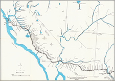
Very early Arizona Territory promotional pamphlet including an unusual pre-1866 map of Arizona inclusive of Mojave County, which would be ceded to the State of Nevada shortly thereafter.
Folding map. 22 pages. 8vo, original printed wrappers with engraved seal of the Territory of Arizona.
The map is titled: "General Outline Map of Arizona." It shows two mines on the American side of the border.
Forts Whipple, Bowie, Goodwin, and Mohave are shown. The towns of Prescott, Weaver, Wickenburg, Pima, Tucson, Tubac, Castle Dome, La Paz, Arizona City, Gila City, Aubrey, Callville, El Dorado Canon, and Wauba Yuma are shown. Much of California is shown in lesser detail.
Arizona is split into Mojave, Yavapai, Yuma, and Pima counties.
Reference
Graff 2593; Howes M65; Sabin 43101; Wagner-Camp 419.
![[Grand Canyon -- Horseshoe Bend] Sketch Map of the Western Part of the Plateau Province Showing the Faults of the Grand Cañon District and High Plateaus](https://storage.googleapis.com/raremaps/img/small/35541.jpg)
![[Arizona below New Mexico] Mexique d'apres le grand Atlas Dresse Par A.H. Dufour Grave par ch Dyonet Pubie par A. Le Chevalier . . . 1863](https://storage.googleapis.com/raremaps/img/small/64395.jpg)
