|
||

|

|
|

|
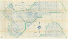
The First Printed Sonoma County Precinct Map
Unrecorded Precinct Map of Sonoma, California, published by local civil engineer JC Parsons.
The voting precincts are outline in pink, with each precinct named. We have been unable to find an earlier printed map focused on Sonoma County precincts.
The map includes a circle around the town of Agua Caliente, referencing the a Franchise of the Sonoma Valley Water Company.
JC Parsons
The map lists JC Parsons as U.S. Deputy Mineral Surveyor * * * Licensed Land Surveyor.
JC Parson seems to have begun his career in Washington in the 1890s.In May 1905, his name appears as a partner in a newly formed Civil Engineering firm with then City Engineer L.E. Richsecker (Santa Rosa Republican). During his career, he would hold the office of City Engineer as early as 1906. By 1908, he was advertising his services as a Surveyor and Blue Printer in the Santa Rosa Republican. By 1914, he was showing up as a County Highway Commissioner. By 1916, he seems to have relocated to Cloverdale.
We note a map of Skagit County, Washington, also done by Parsons in 1894, as well as a map of Cloverdale, California in 1937.
Rarity
The map is apparently unrecorded. We were not able to locate another example.
![[Charles Lindbergh - 1st Trans-Atlantic Flight - Printed on Linen]](https://storage.googleapis.com/raremaps/img/small/69233.jpg)
![(Oil Wells - Santa Fe Springs, Los Angeles County, California) Sante Fee Springs [sic]](https://storage.googleapis.com/raremaps/img/small/95397.jpg)