The item illustrated and described below is sold, but we
have another example in stock. To view the example which
is currently being offered for sale, click the
"View Details" button below.
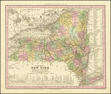
1835 Henry Schenk Tanner
$ 225.00


|
||

|

|
|

|
Stock# 71971
Description
Detailed and interesting map of New York, hand-colored by county and showing towns, rivers, bays, lakes, railroads, roads, mountains, forts, etc.
Tables of steamboat routes and distances and a profile of the Erie Canal.
Tanner's Universal Atlas was the forerunner of a series of American atlases continued by Mitchell; Thomas, Cowperthwait & Co.; Desilver; S.A. Mitchell Jr, and others which extended to the early 1890s.
This map was reissued with changes to the title block into the 1850s.
![[ Middle British Colonies Map ] Pensilvania Maryland and Virginia](https://storage.googleapis.com/raremaps/img/small/98228.jpg)
![[St. Helena] The True Description of the Island of Ascention lyeing under 8 degrees on ye South syde of ye Equinoctiall lyne.](https://storage.googleapis.com/raremaps/img/small/78964.jpg)
![[A chart of New York Island & North River: East River, showing passage through Hell Gate, and the North Shore of Long Island: Flushing Bay, Hampstead Bay, Oyster and Huntington Bay, Cow Harbor]](https://storage.googleapis.com/raremaps/img/small/51531.jpg)