


|
||

|

|
|

|
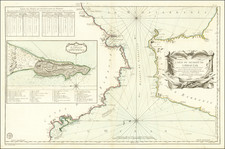
Rare chart of the harbor at Gibraltar and "Algeziras" Bay, published by William Heather in London.
The chart extends from "The Rock of Gibraltar" to Point Cabreta and Algeciras. Various forts are listed.
Includes soundings, some topographical features, anchorages, and several other points of interest.
The map was made during the Napoleonic Wars when Gibraltar was the linchpin in British naval power in southern Europe and the Mediterranean.
Rarity
The charts from Heather's New Mediterranean Pilot . . . are extremely rare on the market. This is the first example of the chart we have ever seen.
Heather's The New Mediterranean Pilot
This small chart comes from the first English attempt at a collection of ports of the Mediterranean, although the genre was well established in France, Italy, and Spain already. The first was published by Joseph Roux in Marseilles in 1764, with versions published in several Italian port cities.
The French and Italian versions were of relatively crude execution, but Heather’s version is notable for the finely engraved charts, many signed in monogram by the London engraver John Stephenson.
![[Great Siege of Gibraltar] Plan Géometral De La Montagne Et De La Ville De Gibraltar : avec une Carte particuliere du Detroit de même nom.](https://storage.googleapis.com/raremaps/img/small/81781.jpg)


![(Siege of Gibraltar) Plan Géometral de la Ville et de la Montagne de Gibraltar Nouvellement Corrigé d'apres les Originaux Anglais [Geometrical Map of the Town and Mountain of Gibraltar, Newly Corrected from the English Originals]](https://storage.googleapis.com/raremaps/img/small/94412.jpg)
![[ Gibraltar ] Plan Topo-Hydrographique de la Baye de Gibraltar](https://storage.googleapis.com/raremaps/img/small/74381.jpg)