|
||

|

|
|

|
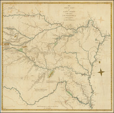
Very rare late state of Bradford's map of the Republic of Texas, the first printed map of the Republic.
Bradford shows the location of a number of the early counties, Indian Tribes, early roads, and towns.
An essential map for Texas collectors, a very rare state of the first reasonably obtainable separate map of the Republic of Texas.
State Differences
The circa 1843 state of the horizontal Bradford Texas includes the following changes:
- Counties are shown, instead of the previously used colonies and grants.
- Texan territory is extended south the Nueces, off of the southern edge of the map.
- Houston is added.
- Austin is added.
- The city of Galveston is now labeled as such, and "Galveston I. and County" is so-labeled.
- Other changes have been made.
Thomas Gamaliel Bradford (1802-1887) was an American geographic publisher. He hailed from Bradford, Massachusetts and began his publishing career by working for the America Encyclopedia. Then, he edited and republished the Atlas Designed to Illustrate the Abridgement of Universal Geography, Modern & Ancient, which had originally been offered in French by Adrian Balbi. In 1835, he published another atlas, A Comprehensive Atlas: Geographical, Historical & Commercial, and, in 1838, An Illustrated Atlas Geographical, Statistical and Historical of the United States and Adjacent Countries. His interests were primarily in educational publishing and he was one of the first mapmakers to show Texas as an independent country.