|
||

|

|
|

|
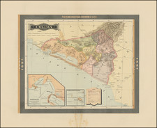
Fine example of the British Admiralty harbor chart for Guaymas and Topolobampo Harbor, on the west eastern coastline of the Gulf of California.
Topolobampo
Topolobampo is a port on the Gulf of California in northwestern Sinaloa, Mexico. The port connects the northern Mexican states through the Chihuahua-Pacific Railroad, which has a terminus in nearby Los Mochis. Topolobampo is also the beginning of the international trade corridor, "La Entrada al Pacifico", that ends near the Midland-Odessa, Texas area.
During the Mexican Revolution, three separate naval battles were fought at Topolobampo in 1914.
Guaymas
In 1539, two Spanish ships, the Santa Agueda and El Trinidad, arrived in Guaymas Bay. They were commanded by Francisco de Ulloa, who called the area "the port of ports."
Some small Jesuit missions in the area were founded in the 1610s and 1620s, when Jesuits founded eight mission villages with the Yaqui. Juan María de Salvatierra and Eusebio Kino asked for permission to evangelize the area, which was received in 1697. In 1701, Salvatierra came to this area and established the Loreto mission somewhat inland from where Guaymas is now. To receive supplies by ship and evangelize the Guaymas Indians, the Jesuits founded another small mission on the bay, which they called San José de Guaymas. The last time this mission was abandoned was in 1759.
In 1767, Viceroy Marqués de Croix ordered a major military offensive, the Sonora Expedition, to subdue the Seri and Pima tribes. After doing so, the Spanish colonials built an adobe fort with four towers in Guaymas, initially under the command of Captain Lorenzo Cancio. Around the same time, the colonists formally mapped the Guaymas Bay and officially founded the city of Guaymas in 1769 by José Gálvez in Real de Alamos on behalf of the viceregal government. Despite the decree, no colonists settled there until the early 19th century.
At the beginning of the 19th century, the village began to be populated by farmers and ranchers, who held large properties but did not have markets for their products. Farming was on a subsistence level. In 1811, commercial maritime traffic was authorized, and customs were established later in 1823. Ships visited the bay intermittently but only one house was here for customs purposes. I The first commercial imports came through here in 1827.
The port became a municipality in 1825. During the Mexican–American War, American warships such as the Portsmouth, the Congress, the Dale and the Argos anchored here near the Pajaros Island and the Almagre Grande. The ships fired on the town and captured it, keeping it in U.S. hands from 1847 to 1848.
In the mid-19th century, Guaymas was the target of several filibusters (unauthorized military expeditions from foreign nations), designed to foment rebellion. One was done by the crew of the English sailing vessel “Challenge” and a French ship named La Belle commanded by Count Gastón Raousett-Boulbón, who intended to take over all of Sonora. The French attacked the city on July 13,1854, but the port was successfully defended by José María Yáñez. The national government elevated the town to city status as a reward for this action in 1859. Later, in 1935, it gave Guaymas the title of “heroic city” for the same action. In 1865, French ships arrived to attack Republican forces, which were forced to retreat. The French occupied the city until 1866.
During the Mexican Revolution, the first ever aerial bombardment of a naval target occurred just off the coast of Guaymas: in 1913, five military ships belonging to Federal forces appeared in the bay, and General Alvaro Obregon of the rebel army ordered the bombing of these ships using the aircraft “Sonora.”
The British Admiralty has produced nautical charts since 1795 under the auspices of the United Kingdom Hydrographic Office (HO). Its main task was to provide the Royal Navy with navigational products and service, but since 1821 it has also sold charts to the public.
In 1795, King George III appointed Alexander Dalrymple, a pedantic geographer, to consolidate, catalogue, and improve the Royal Navy’s charts. He produced the first chart as the Hydrographer to the Admiralty in 1802. Dalrymple, known for his sticky personality, served until his death in 1808, when he was succeeded by Captain Thomas Hurd. The HO has been run by naval officers ever since.
Hurd professionalized the office and increased its efficiency. He was succeeded by the Arctic explorer Captain William Parry in 1823. By 1825, the HO was offering over seven hundred charts and views for sale. Under Parry, the HO also began to participate in exploratory expeditions. The first was a joint French-Spanish-British trip to the South Atlantic, a voyage organized in part by the Royal Society of London.
In 1829, Rear-Admiral Sir Francis Beaufort was appointed Hydrographer Royal. Under his management, the HO introduced the wind force scale named for him, as well as began issuing official tide tables (1833). It was under Beaufort that HMS Beagle completed several surveying missions, including its most famous voyage commanded by Captain FitzRoy with Charles Darwin onboard. When Beaufort retired in 1855, the HO had nearly two thousand charts in its catalog.
Later in the nineteenth century, the HO supported the Challenger expedition, which is credited with helping to found the discipline of oceanography. The HO participated in the International Meridian Conference which decided on the Greenwich Meridian as the Prime Meridian. Regulation and standardization of oceanic and navigational measures continued into the twentieth century, with the HO participating at the first International Hydrographic Organization meeting in 1921.
During World War II, the HO chart making facility moved to Taunton, the first purpose-built building it ever inhabited. In 1953, the first purpose-built survey ship went to sea, the HMS Vidal. Today, there is an entire class of survey vessels that make up the Royal Navy’s Hydrographic Squadron. The HO began to computerize their charts in the late 1960s and early 1970s. In 1968, the compilation staff also came to Taunton, and the HO continues to work from there today.