


|
||

|

|
|

|
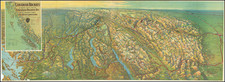
Bailey Willis Maps the Region West of Mount Rainier
Large geological map of the region between Tacoma and Mount Rainer, signed by a then 25 year old Bailey Willis.
The map provides an early detailed look at the geology of the region, at a time when the Northern Pacific Railroad was investigating the Coal mining prospects of the region, with yellow designating Quaternary, Greens for Lignite Measures and Bituminous Coal Measures and Pink for Volcanic regions.
In addition to the geological features shown on the map, the map shows the hydrography of the region, with the line of the Northern Pacific and some early towns shown.
A road extends from Tacoma to Wilkeson and Carbonado, which appear to be the principal coal regions on the map. From these points, several trails, cabins and proposed cabins extend to the south toward the South Fork of the Puyallup River designated as Meadow Camp, due west of Mt. Tacoma (Rainier).
Drawn in 1882, this map is perhaps the earliest surviving printed map undertaken by Bailey Willis (here spelled Baily), who would go on to become one of America's most important geologists of the 20th Century and one of the world's foremost experts on earthquakes and seismology.
The map also takes on a romantic air in Bailey Willis's storied career. During his first few years in the field, Willis spent time beginning in 1882 in Washington, during which time he explored the area west of Mt. Rainier by horseback and canoe. He also led several VIP parties through the region, including General Sherman's party on Sherman's final tour through the west. This early work clearly inspired Willis's lifelong passion for the region and was instrumental in shaping his career. Prior to Willis' exploration of the region, the area was still largely unexplored and unmapped.
Willis was one of the primary protagonists in persuading the Federal Government to designate Mt. Rainier as a national park. Willis, at the time a geologist and mining engineer with the United States Geological Survey, started the campaign in 1893. More than a decade earlier, in 1880, Willis had prospected for coal deposits for the Northern Pacific Railroad near the northwest flank of Mount Rainier, cutting a trail from upper Carbon River to Spray Park, above which looms Rainier's immense cavitated north face, now known as Willis Wall. He returned to the mountain whenever the opportunity presented itself. In 1893, at the annual meeting of the Geological Society of America, Willis proposed to his fellow geologists that they initiate an effort to have the area preserved in a national park. The society formed a committee and appointed Willis chairman.
Rarity
The map is apparently unrecorded.
The earliest printed map bearing Willis' name in OCLC is dated 1892. The Clements Library holds a small undated manuscript entitled Cross Sections of the Smith Vein, Smith Property, Wilkeson W.T., which is undated, but certainly from the same 1880-1884 period.
Bailey Willis was a geological engineer who worked for the United States Geological Survey (USGS), and lectured at two prominent American universities. He also played a key role in getting Mount Rainier designated as a national park in 1899. After later focusing more on seismology, he became one of the world's leading earthquake experts of his time.
Bailey Willis was the son of poet and publisher Nathaniel Parker Willis and Cornelia Grinnell Willis. At 13, he was taken to England and Germany for 4 years of schooling, and thus acquired fluency in German at a time when many scientific texts were only available in that language. He entered Columbia University and in 5 years completed his studies with the degrees in mechanical (1878) and civil (1879) engineering.
In 1879, he met Clarence King, who was then organizing a new US Geological Survey. King referred Willis to Raphael Pumpelly, one of the
earliest economic geologists in the United States, who had recently returned from China and was then in charge of the survey for the projected Northern Pacific Railroad. Hired by Pumpelly, Willis spent the next few years in estimating deposits of coal and iron ore in remote parts of the southern Appalachian mountains, northern Minnesota, Montana, and Washington.
As noted by Blackwelder:
Much of the time he was alone, except for native helpers, traveling by canoes, on horseback, or on snowshoes, and living the strenuous life of die wilderness. It was difficult work, which called forth all the stamina and ingenuity at his command. In 1882
he visited the slopes of Mount Rainier with a distinguished party which included General Miles and General Sherman. In the following year he led another party of notables, among whom were Sir James Bryce and Baron Karl von Zittel, to the same locality. Fourteen years later, in company with I. C. Russell, he made one of the first ascents of the great volcano.
Willis explored and mapped the northern slopes of Mt Rainer. "To this day, people who visit the northern slopes, and parks of the mountain become familiar with the Bailey Willis trail and from Moraine Park they get a view of the wonderful Willis Wall named in his honor." (Meany, 1916, 142). He gave a brief statement of the results of his observations in the now extinct magazine, The Northwest for April, 1883, under the title, "Canyons and Glaciers. A Journey to the Ice Fields of Mount Tacoma."
After the railroad company went bankrupt in 1884 Wills joined the U. S. Geological Survey under Major Powell. During that interval he had an inspiring association with G. K. Gilbert, noted explorer of the Great Basin, who was then Chief Geologist. From 1884 to 1915, he worked for the USGS, being named director of the Appalachian division in 1889. In 1893 he published The Mechanics of Appalachian Structure in the Report of the United States Geological Survey.
From 1895 to 1902, Willis lectured on geology at Johns Hopkins University. In 1900 he was appointed head of the Division of Areal Geology of the USGS.
In 1903, Willis received a grant of $12,000 from the newly established Carnegie Institution of Washington to lead an expedition to northern China, an experience which was later described in his book Friendly China. From 1910 until 1914 he consulted for the government of Argentina, an experience later recorded in his book A Yanqui in Patagonia.
When he returned to the United States in 1915, Willis was named Head of the Stanford University Geology Department. He led a vigorous public campaign in the 1920s to raise awareness of earthquake hazards and safe building practices. It is claimed that many of California's early building codes were inspired by experiments performed by Willis on an "earthquake table" at Stanford University. Willis, concerned about the dangers of earthquakes convinced engineers to dig the foundation of the southern tower of the Golden Gate Bridge deeper.
After finishing his work with the USGS, he was appointed as a professor and chairman of the geology department at Stanford University, where he served until 1922. In 1920, he was elected to the National Academy of the Sciences. He was president of the Seismological Society of America from 1921 to 1926, during which time he published his Geologic Structures. He was president of the Geological Society of America in 1928.
On July 11 1927, while in Cairo, he heard that a destructive earthquake struck the Holy Land. The day after, he took a private flight from Cairo to Palestine, made observations of the impacted sites, and stayed there for several days to further investigate. A year later, he published his findings in the Bulitin of Seismological Society of America.
In 1928, Willis published Continental Drift in the SP 2: Theory of Continental Drift, by the American Association of Petroleum Geologists, where he rejects the theory. Stating "After considering the theory of continental drift with avowed impartiality, the author concludes by means of geophysical, geological and paleontologic reasoning that it should be rejected, because the original suggestion of the idea sprang from a similarity of form (coast lines of Africa and South America) which in itself constitutes no demonstration, because such a drift would have destroyed the similarity by faulting, and because other contradictions destroy the necessary consequences of the hypothesis."
In 1932, he published Isthmian Links in the Bulletin of the Geological Society of America.
The Bailey Willis papers, 1882-1896, reside at Duke University.
![[Washington] Map of West Okanogan Valley Irrigation District](https://storage.googleapis.com/raremaps/img/small/89722.jpg)
