This item has been sold, but you can enter your email address to be notified if another example becomes available.


|
||

|

|
|

|
Stock# 71825
Description
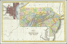
Rare Early 19th-Century Map of Philadelphia and the Nearby Delaware River.
A fine example of John Luffman's rare map of the Philadelphia area, published in London in 1802.
The map extends from Kensington in the north to Chester in the south, covering Mud Island and the nearby Revolutionary War-era fort.
The text at the bottom notes:
Philadelphia the Capital of the State of Pensylvania was founded by William Penn in 1632, The Delaware is navigable up to the City for large ships.
Rarity
Maps by John Luffman are very scarce on the market, this being the first time we have had this one.
Condition Description
Original hand-color.
![[ Plasterers Company -- Certification of Master Plasterer Edward Evans ]](https://storage.googleapis.com/raremaps/img/small/97322.jpg)