


|
||

|

|
|

|
Guillaume Levasseur de Beauplan Maps The Ukraine
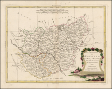
Very rare Sanson map of "Russie Rouge" extending from the Carpathian Mountains to Lublin Poland and Ratney in Volyn Oblast of Ukraine.
The map tracks the southern part of the modern Poland - Ukraine Border.
"Russie Rouge" or Red Ruthenia or Red Rus' is a term dating back to the Middle Ages, which was used to refer to the southwestern polities of the Kievan Rus', which include parts of present-day western Ukraine and southern Poland. On this map the area is split between the Palatinate of Lemberg and the Palatinate of Belcz.
States / Rarity
The first state was published in 1665, under a different title (Russie Noire). A 1674 state has the present title but lacks the decorative border on the cartouche and the longer imprint line. This state was published by Sanson's heirs.
All states are rare.
This is the first time we have offered the map for sale. Maps which name and focus on Red Ruthenia are very rare.
Guillaume Levasseur de Beauplan
Beauplan was a French geographer and military engineer who went to Poland at the invitation of King Sigismund III and spent 17 years building fortresses and castles as well as surveying parts of Ukraine. He was active mainly on the eastern frontiers, where he supervised the building of fifty fortresses and set out hundreds of villages. In 1639, he participated in a surveying expedition down the river Dnieper. About this time, he drew a sketch map of southern Ukraine, the “Tabula geographica Ukrainska,” which has been preserved in the “Topographica practica,” a collection of manuscript maps and charts assembled by Frederick Getkant by order of Ladislaus IV.
Beauplan made a general map of Ukraine with Henricus Hondius, Delineatio generalis camporum desertorum vulgo Ukraina cum adiacentibus provinciis, which was published in Gdansk in 1648. In 1651, he published a description of Ukraine, which was limited to the Crimea and the lower course of the Dnieper and was printed in only one hundred copies. After years of work, Beauplan had expected a generous reward for his services, but King Ladislaus IV died in March 1648, dashing any hope of compensation. In 1654 John II (John Casimir) of Poland granted Gdansk printer Georg Förster and historian Joachim Pastorius the privilege to print the maps and the description of the kingdom’s provinces—in other words, to finish the work Hondius and Beauplan had started.
Beauplan wrote Description des contrés du Royaume de Pologne, which was published in 1651. The work was retitled Description d'Ukranie, when the second edition was released in 1651. Two more editions were published in 1660 and 1861. The book was the first book published that provided a geographical, economic, and demographic description of Ukraine.
Nicholas Sanson (1600-1667) is considered the father of French cartography in its golden age from the mid-seventeenth century to the mid-eighteenth. Over the course of his career he produced over 300 maps; they are known for their clean style and extensive research. Sanson was largely responsible for beginning the shift of cartographic production and excellence from Amsterdam to Paris in the later-seventeenth century.
Sanson was born in Abbeville in Picardy. He made his first map at age twenty, a wall map of ancient Gaul. Upon moving to Paris, he gained the attention of Cardinal Richelieu, who made an introduction of Sanson to King Louis XIII. This led to Sanson's tutoring of the king and the granting of the title ingenieur-geographe du roi.
His success can be chalked up to his geographic and research skills, but also to his partnership with Pierre Mariette. Early in his career, Sanson worked primarily with the publisher Melchior Tavernier. Mariette purchased Tavernier’s business in 1644. Sanson worked with Mariette until 1657, when the latter died. Mariette’s son, also Pierre, helped to publish the Cartes générales de toutes les parties du monde (1658), Sanson' atlas and the first French world atlas.
![[ Ethnographic Thematic Atlas - Poland, Lithuania, Ukraine, etc. ] Völker-Verteilung in West-Russland (Distribution of Peoples in Western-Russia)](https://storage.googleapis.com/raremaps/img/small/94045.jpg)
![[ Holy Roman Empire ] A New Map of the German Empire, and the Neighbouring States with their Principal Post Roads, Originally Published by the Royal Academy of Berlin . . . 1788](https://storage.googleapis.com/raremaps/img/small/102913.jpg)