|
||

|

|
|

|
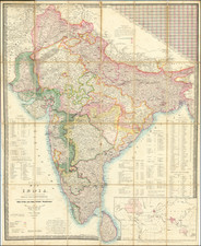
Nice example of the 1879 edition of William Allen & Co's enduring large format map of India.
This is a marvelous map of India, showing the subcontinent divided according to the various political powers which controlled it at the time.
This example of the map has been annotated in blue and black by an early hand, locating additional railroads and prospective rail road lines with a dashed line.
The map contains extensive information, with thousands of cities and towns named. Roads, mountain ranges, rivers, lakes, and more are all shown. Perhaps most useful is the long list in the lower left of the map detailing which provinces are controlled by what colonial powers. British colonies obviously dominate this list, with twenty-six such possessions. Other European powers controlling territories are France, Denmark, and Portugal. Only four independent states are left in the region: Scindia, Nepal, Lahore, and Cabool.
The map was published near the completion of the Great Trigonometrical Survey of India. Initial British mapping of the subcontinent was limited in accuracy, and so a modern survey was undertaken. The survey commenced in 1802 and was continued under George Everest. Through a very extensive and arduous series of triangulations, the survey was able to rectify the shape of the subcontinent on maps and provide accurate distances from one point to the next.
![[Nagpada, Mumbai -- Includes Jewish Cemetery] Plan of the Property . . .](https://storage.googleapis.com/raremaps/img/small/84401.jpg)
![[Karaikal] Carte Reduite du Territoire de Karikal](https://storage.googleapis.com/raremaps/img/small/59318.jpg)