


|
||

|

|
|

|
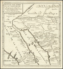
Detailed map of the region of Mexico lying between the Gulf of Mexico and the Pacific Ocean.
The map was drawn with a view toward the potential for travel and navigation across the Isthmus.
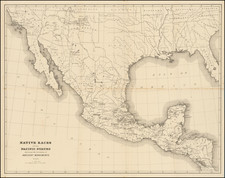
Duflot de Mofras had been sent to Mexico in 1839 ostensibly to act as French Ambassador. His real motive was to provide the French government with information about the Pacific Coast of North America to help decide whether or not to become embroiled in the conflict over Oregon between the United States and Britain. His description includes the western coast of America from Tehuantepec to the Bering Strait, and considers the Spanish voyages of discovery, Vancouver Island, and the Fraser River.
The atlas includes "A Landmark" Map of the West "by a Frenchman . . . intent upon forwarding the interests of France on the Pacific Coast" (Wheat)
Extending from Mount St. Elias to Acapulco in the west and from Austin Texas, Ft. Leavenworth and Hudson Bay in the east, the map is a masterpiece of contemporary observations and assiduous compilation. Wheat refers to the map as "A landmark . . . because it made these western regions known in European official circles. . . "
Duflot de Mofras was very interested in travel routes. East of Santa Fe he noted the 'Route des Chariots des Etats-Unis', and the route which would later become popularly referred to as 'The Old Spanish Trail.' Wheat states that this beautifully engraved map was often used by European cartographers as the basis for early gold-rush period maps of California and neighboring territory." Rumsey notes that Wheat neglects to mention the similarities between Duflot de Mofras' map, and the rare 1837 edition of John Arrowsmith's Map of British North America. While not a copy of the Arrowsmith, it clearly followed the Arrowsmith map in many respects.
The detail in the map and its annotations are far reaching, with a uniquely global approach to the region. Rather than focusing on the geo-political or other features of any single region, the map provides fine detail in topics as far reaching as the Russian possessions along the West Coast, the Hudson Bay Company's control and dominance of Western Canada, the independence of Texas (including the illustration of several land grants), the growing fur trade west of the Missouri River, and of course phenomenal contemporary detail in California and Oregon Territories, 5 years prior to the Gold Rush.
The Isthmus of Tehuantepec is an isthmus in Mexico. It represents the shortest distance between the Gulf of Mexico and the Pacific Ocean, and prior to the opening of the Panama Canal was a major shipping route known simply as the Tehuantepec Route.
Eugene Duflot de Mofras was a traveler, naturalist, diplomat, and spy. In 1839, du Mofras was appointed attaché to the French delegation to the Mexican government. While there, he was tasked with visiting the northern areas of Mexico; he was sent both as an official visitor but also as a veritable spy, gathering intelligence as to likely places to establish French trading posts. In 1844 he published an account of his travels, complete with an influential map of western North America.
![(California and Mexico) [Album of 68 original photographs (including 42 panoramic views): a train wreck in California; San Francisco earthquake damage; Torreon; Aguascalientes; Mexico City and more]](https://storage.googleapis.com/raremaps/img/small/98220.jpg)
![(Yucatan) Indien contrebandier de l'interieur [Indian Smuggler from the Interior]](https://storage.googleapis.com/raremaps/img/small/86592.jpg)